Cold Springs Peak Cabin - Clearwater Nf (ID)
Cold Springs Peak Cabin - Clearwater NF (ID)
Part of Nez Perce-Clearwater National Forests
Overview
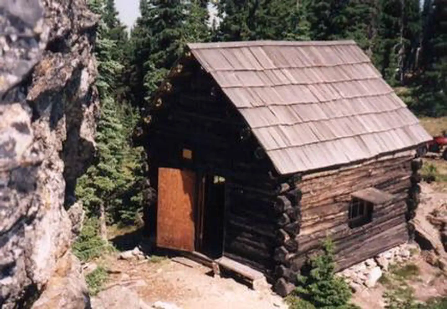
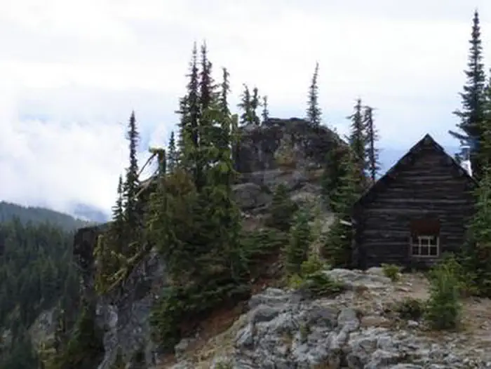
As a qualifying inclusion to the National Register of Historic Places, the primitive 12'x14' log cabin was originally constructed to shelter firefighters and other work crews in 1931. Although Forest Service personnel and volunteers shored up the cabin’s foundation, re-shingled the roof and installed a wood heating stove, guests must bring their own supplies and gear for a comfortable stay as there are no linens, cleaning supplies, or toiletries provided. The popular cabin is perched on a ridge line just off Pot Mountain trail #169 overlooking the Elizabeth Creek drainage and Ice Lake. The trailhead to the cabin is not assessable with low clearance vehicles, and the 2 plus miles of trail from the trailhead to the cabin is a moderately difficult, multi-use trail with several steep grades. Although assessable by OHV's less than 50" in width, the roads and trails leading to the cabin can be partially or fully blocked by debris or snowpack in the early season. Off trail/road motorized travel is strictly prohibited. Visitors are strongly advised to consult the forest website, as well as a map prior to reserving or traveling to the cabin and to call the district information desk with any questions.
Facilities
The cabin is a 1930’s primitive structure only providing a shelter from the elements. Two spring beds, a small table with a couple chairs, a modern wood stove, and a pit toilet outhouse are the only amenities provided. There is only one stream as a reasonable water source approximately 1 mile from the cabin on trail #169 that requires treatment before consumption. Guests are required to pick up after their pets/stock, pack out their trash, and clean the cabin before they check-out with the provided broom under the “Leave it Cleaner than when you arrived” and the “Pack it in Pack it out” policies so everyone may enjoy their stay.
Natural Features
The cabin is tucked into a narrow, rocky saddle, atop steep, nearly vertical cliffs directly adjacent to Cold Springs Peak. At almost 6,731 feet, guests enjoy open views of the Bitterroot Mountains to the east as well as a bird’s eye view of the Elizabeth Creek drainage, Ice Lake, and a small meadow directly below the cabin. The area boasts a wide diversity of wildlife and birds, so visitors never know what to expect while enjoying the scenery, but mule deer, mountain lion, black bear, elk, Mountain Bluebird, Mountain Jay, Raven, and Tanager are the most common. Seasonal changes can be particularly enjoyable as the storms blow through the saddle, or the extraordinary fall colors back dropped with mountains capped by advancing snow late in the season.
Recreation
Due to the unique location, the cabin is an ideal base camp for those looking to reconnect with nature, or as a stopover for a variety of outdoor enthusiasts as they explore the district. Multiple mountain lakes in the vicinity provides a welcome challenge for the avid adventurer looking to find the many secluded fishing holes. There are also several other trails in the vicinity that offer connection to a host of recreation opportunities including; berry picking, hiking, biking, sightseeing, and birding being the most popular. Recreate responsibly, be sure to check the regulations and rules to educate yourself before you recreate by visiting https://idfg.idaho.gov/ and https://www.fs.usda.gov/news/nezperceclearwater/news-events for up to date information.
Nearby Attractions
The North Fork ranger district prides itself on the diversity of world class recreational opportunities ranging from bird/wildlife watching, big game hunting, whitewater rafting, leisurely floats, secluded backpacking/equestrian trails into the high mountain backcountry, to motorized OHV trail systems providing unique experiences that draw visitors from around the world and all walks of life.
Contact Info
For facility specific information, please call (208) 476-4541.Important Notices
No water is available at the cabin.
Consider the risks inherent to the cabin's location before deciding whether to bring children.
Please pack out trash.
No railings or fences surround the cabin.
Those considering renting the Cold Springs Cabin are strongly encouraged to contact the North Fork Ranger District Office (208) 476-4541 for more information and to purchase a Clearwater National Forest map.
Click here for more information about Nez Perce-Clearwater National Forests.
- Don't Move Firewood: Prevent the spread of tree-killing pests by obtaining firewood near your destination and burning it on-site. For more information visit dontmovefirewood.org.
Available Activities
- Wildlife Viewing - Wildlife Viewing
- Horseback Riding - Horseback Riding
- Hiking - Hiking
- Fishing - Fishing
- Camping - Camping
- Biking - Biking
- Berry Picking - Berry Picking
- Backpacking - Backpacking
- Birding - Birding
- Fire Lookouts/Cabins Overnight - Fire Lookouts/Cabins Overnight
- Hunting - Hunting
- Mountain Biking - Mountain Biking
- Mushroom Picking - Mushroom Picking
- Organization Site Fs Owned - Organization Site Fs Owned
- Scenic Drive - Scenic Drive
- Star Gazing - Star Gazing
- Historic & Cultural Site - Historic & Cultural Site
Directions
<p>The cabin is approximately 50 miles northeast of the community of Pierce, Idaho on the North Fork Ranger District of the Nez Perce-Clearwater National Forest. The last 35 miles to the cabin from Pierce are mostly single lane, gravel surfaced roadways that may be peppered with large potholes and rocks, with the last 6 miles being rutted 2 track road requiring 4X4 high clearance vehicles operated by experienced operators and 2 miles of multi-use, moderate difficulty trail. <strong>Seasonal conditions permitting:</strong> Cold Springs Cabin is also approachable from I90 via Superior MT, with the addition of a high mountain pass that is usually impassible from late Oct to mid-July, and 60 miles of challenging gravel/rock/dirt road conditions. Visitors are strongly advised to consult a map, the forest web site, seasonal conditions in advance of making reservations as well as prior to travel, and to plan their trip accordingly as there are no services on the forest.</p> <p>To approach Cold Springs Cabin from Idaho via US HWY 12 and State HWY 11: Locate French Mountain Road, also known as Forest Service Road 250 on the east side of State HWY 11 (Main St) on the south end of Peirce Idaho (approximately 3/4 of a mile from city center). Travel on FSR 250 for approximately 45 miles (be sure to stay to the right after crossing the North Fork of the Clearwater River at the “Historic Bungalow Ranger Station site”) until you reach the FSR 250 and FSR 711 junction at Cold Springs Cr (about 2 miles West of Kelly Forks Work Center)</p> <p>From the FSR 250/FSR 711 junction, at Cold Springs Cr follow FSR 711 to the Junction of FSR 711/FSR 5295. At this point the remaining 6 miles to the Cold Springs Cabin becomes increasingly narrow, steep, rocky, rutted and brushed in travel, barely passable with high clearance 4x4 vehicles with an experienced operator during the best of conditions, so it is recommended to continue by ATV/UTV, motorbike, or on stock/foot following the established FSR 5295 to FSR 5297 route leading to the Flat Mountain Trailhead of the 176 trail. Follow the multi-use, moderate difficulty 176 trail 2 miles, and past the junction of the Elizabeth Mountain 445 trail to the east (at about the halfway point) to the Cold Springs Cabin. </p> <p><strong>Conditions permitting:</strong> Cold Springs Cabin can be approached from USI90 via Superior MT by locating the River St under pass of USI90. Follow River St to Diamond Match Rd on the south side of USI90, follow Diamond Match Rd southeast past Riverbend where the road curves to the south and becomes FSR 250, travel 25 miles (also known as the Trout Creek Road) to Hoodoo Pass at the Idaho-Montana state line. Continue southwest on FSR 250 for approximately 29 more miles past the FSR 250/FSR 255 junction and thru Black Canyon to the Kelly Forks Work Center, then continue on FSR 250 to the FSR 250 and the FSR 711 junction at Cold Springs Cr (about 2 miles west of the Kelly Forks Work Center) and follow directions in the paragraph above. </p> <p><strong>*NOTE:</strong> Hoodoo Pass, is a remote mountain pass that rises to 6,000 ft elevation and is typically impassable due to snow from late Oct until mid-July when the pass melts out. Black Canyon typically has spring debris slides that can make FSR 250 between Hoodoo pass and Kelly Forks Work Center impassible until cleared. An alternate route is to take FSR 255 through Deception and then follow it along Kelly Creek back to FSR250.</p>
Contact Information
Phone: 208-476-4541
12740 HWY 12OROFINO, ID 83544