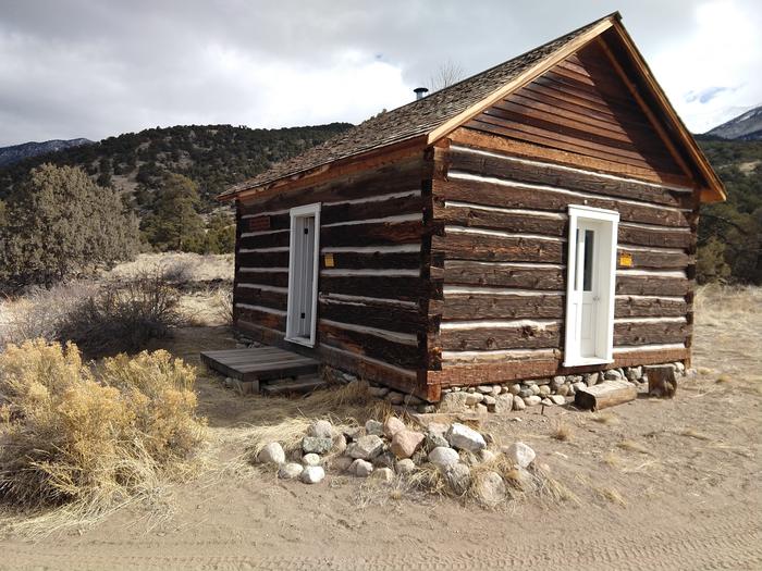
Duncan Cabin
The cabin was construction (estimated 1880s.) The cabin sits 8,120 feet above sea level beside a small dry stream‐bed. The nearest source of water is Pole Creek which is approximately 1,500 feet from the cabin. The cabin sits on a west‐facing gently sloping grade that looks out onto the San Luis Valley. Although large coniferous trees are located near the cabin, the vegetation is primarily Rabbitbrush, Pinon, and Juniper.
The one-room cabin is furnished with two bunk beds (the top bunk is a single bed, the bottom is a fold-out futon couch that sleeps two) and can accommodate up to 6 people. The cabin has a wood stove, a table and chairs, cooking utensils and some pots and pans. A picnic table, fire pit and an outdoor vault toilet are also on site. There is no electricity and water at the cabin. Water is also available at the Saguache Ranger District Office during business hours from May through November.
Need to Know
• Please contact the Saguache Ranger District prior to arriving at the cabin to check on any restrictions or conditions, such as fire or road closures, weather or storms that may affect the quality of your visit.
The maximum stay limit on the forest is 14 days. You may be visited by a Forest Employee during your stay, for routine cabin safety check and maintenance/cleaning. If you wish to not be disturbed, a door tab will be available to use.
• This site is only allowed to be accessed by hiking, bicycling (NO E-BIKES), or horseback for visitors. The travel distance is 4 miles using the road, which consists mostly of sand and rocky terrain and a stream crossing. No vehicle access.
• Horses are allowed, there is a corral to use. Recommended number is 2. Maximum number of allowed horses is 3. When using the corral, manure must be spread out, and hay/grass MUST be certified noxious weed free.
• Entry to the cabin is by combination lock, which will be provided in the confirmation letter or email which is sent after a reservation is made.
• Water is currently NOT available at the guard station. Water is available at the Saguache Ranger District office during business hours from Memorial Day weekend to November.
• There is no electricity at the Guard Station, however there is cell phone service available at this facility. Bring extra batteries and light sources.
• The guard station is a non-smoking facility.
• Pets are allowed at the facility but must be always under control; they must not harass wildlife or livestock. Do not allow pets on furniture; pet hair is very difficult and can cause allergic reactions.
• All garbage and food must be packed out; do not burn garbage in the fire pit or wood stove. DO NOT leave food or trash outside the guard station other than the installed trash bins; there are bears and other scavenger animals in the area.
• This facility does not have propane for heating or cooking; Bring a backcountry cook stove. A fire ring and wood stove is at the site; just bring/collect your own local firewood. Make sure the fire is out.
• Please clean the guard station and ensure the door is locked upon departure.
• Drink plenty of water before arrival and during your stay to avoid altitude sickness.
• For safety and resource protection, do not discharge firearms and skeet shooting is prohibited within 150 yards from the cabin area.
Natural Features
This area also provides habitats for large herds of elk, pronghorn and mule deer. It is also close to the Great Sand Dunes National Park.
Nearby Attractions
The Duncan cabin is located in the Rio Grande National Forest 11.8 miles southeast of Crestone, CO. There is a lot of hiking trails in this area. The Great Sand Dunes National Park is also close by.
Recreation
The cabin is a good base camp for horse riding. It does have a corral close to the cabin. It is a good place for hunting, hiking and watching the night sky. It is close to the Great Sand Dunes National Park that is designated as an international Dark Sky Park.
Contact Information
Mailing
46525 State Hwy 114 Saguache CO 81149
Phone Number
For campground inquiries, please call: (719) 655 - 2547
Rental Options
Learn more about gear rental options for your trip
Driving Directions
Duncan Cabin cab be reached from Moffat, Colorado, on State Highway 17, either 37 miles from Alamosa or 14 miles from the intersection of US Hwy 285 between Saguache and Salida. From Moffat turn towards Crestone (County Road T), for 12 miles. Before getting to Crestone, turn right at Camino Baca Grande Road for 2 miles. Turn right at Camino Real Road (no street signs, but look for small brown sign saying "Liberty Road" on the right side. Follow Camino Real for 3.4 miles, look for another small brown sign reading "Liberty," turn left at Camino Del Ray. Follow that road up to the top of the hill, roughly 2.5 miles, until the road comes to a left or right turn. Look for the brown "Liberty" sign on the right side of the road, and turn right at Camino Baca Grande.
Note that pavement ends on Camino Baca Grande Way, continue on that road until you get to a narrow gateway with Forest System Road 952. Road becomes very rough and bumpy for the remaining 5 miles to Liberty Gate. From there is hiking/cycling/horseback only, for the 4 miles to the cabin. Note, stream crossing 2 miles from Liberty Gate. Be sure to stay on FSR 952, there's a turnoff road going to Deadman Creek, approximately 0.3 miles from Liberty Gate. Keep right of the turnoff.