Glory Hole Recreation Area
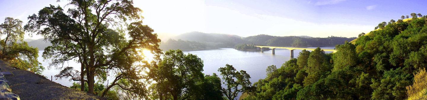
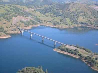
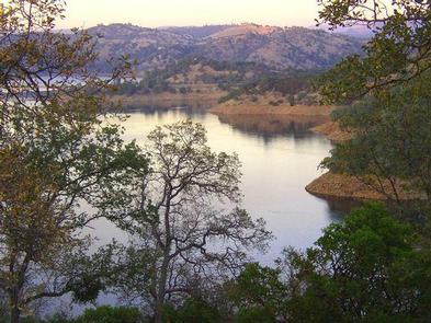
Glory Hole Recreation Area is located at New Melones Lake on the Stanislaus River. The 12,500 surface-acre lake is the fourth largest reservoir in California and is situated along the edge of the Mother Lode, the rich gold vein that prompted the California Gold Rush of 1849. At an elevation of 1100 feet, the diverse and resource-abundant Foothill Oak Woodlands hug the 100 miles of shoreline. Popular activities on and around the large, yet uncrowded lake include fishing, boating, water skiing, wake boarding, jet skiing, sailing, swimming, kayaking, canoeing, wildlife viewing, rock climbing, hiking, biking, horseback riding and picknicking. The New Melones Visitor Center offers year-round interpretive events and a museum highlighting natural and cultural resources.
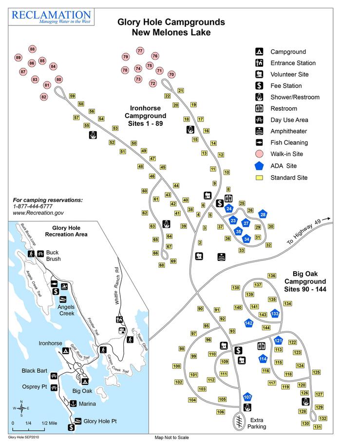
The campground provides modern amenities like flush toilets, showers and drinking water. Visitors will also find a full-service marina, boat launch, day-use areas, barbeque grills and a fish cleaning station. There is an amphitheater for Ranger programs and horseshoe pits in the Ironhorse campground. Picnic tables and fire rings are provided at each campsite.
Recreation Area entrance gates close at 9:00 PM, and open at 4:00 AM. Exit gates are never closed.
Notifications and Alerts
The Glory Hole dump station and fish cleaning stations are closed.
Need to Know
The entrance station is closed, please proceed to your reserved campsite. There will be a reservation tag and 1 or 2 hangable vehicle tags clipped to your campsite's post. Please leave the reservation tag on the post and place the vehicle tag(s) inside your vehicle(s). Please find a Camp Host or Park Ranger if you have questions.
Recreation area entrance gates close at 9:00pm.
Vehicle entry after the gates are closed is prohibited. Exit at any time.
All vehicles must stay on paved roads and parking spots.
Two vehicles permitted in standard campsites. One vehicle permitted in walk-to sites. All vehicles within the campgrounds must display a campground vehicle tag OR an overflow vehicle parking receipt.
Check in time is 3:00pm. Check out time is 2:00pm.
Switching campsites after check-in is not permitted. Please contact a Park Ranger.
The dump station is an additional $8 for registered campers or $4 for Senior/Access pass holder campers. Please pay using the automated fee station at the park entrance or by paying on Recreation.gov.
Camping fees include boat launch fees. Please ensure your vehicle is displaying a valid vehicle pass in your vehicle.
Campfires are only allowed in fire rings or grills in designated areas.
During National Weather Service "Red Flag Warning" days, wood and charcoal fires will not be permitted.
At New Melones Lake there is a 14 day camping limit within a 30 day period.
Showers are located in each campground and are $0.50. Please bring your own quarters.
If New Melones Lake elevation is below 870', boat ramps are not available. "Water front" campsites may also not be available. Park maps depict an elevation around 1050 feet.
Current lake elevation: http://cdec.water.ca.gov/dynamicapp/QueryMM?Stations=NML&SensorNums=6&End=2021-07-19&span=1+month
While recreating at New Melones Reservoir:
CLEAN, DRAIN, DRY boats and any other recreational equipment that comes in contact with water. Never dump unwanted bait, worms, fish parts or other organisms into the water. For more information visit https://www.invasivespeciesinfo.gov/
STOP THE SPREAD OF INVASIVE SPECIES. REMOVE plants, seeds, animals and mud from boots, gear, pets, and vehicles. CLEAN your gear before entering and leaving the recreation site. STAY on designated roads and trails and use local firewood. For more information visit https://www.invasivespeciesinfo.gov/
Natural Features
New Melones Lake is located in Northern California between the historic gold rush towns of Sonora and Angels Camp. The terrain varies from rolling hills to steep marble cliffs, and the vegetation consists of oaks, Ponderosa pines, chamise and buckbrush shrubs.
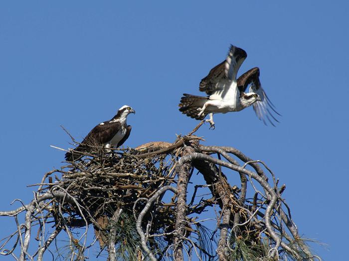
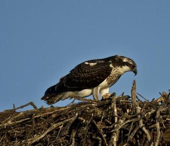
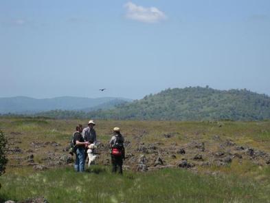
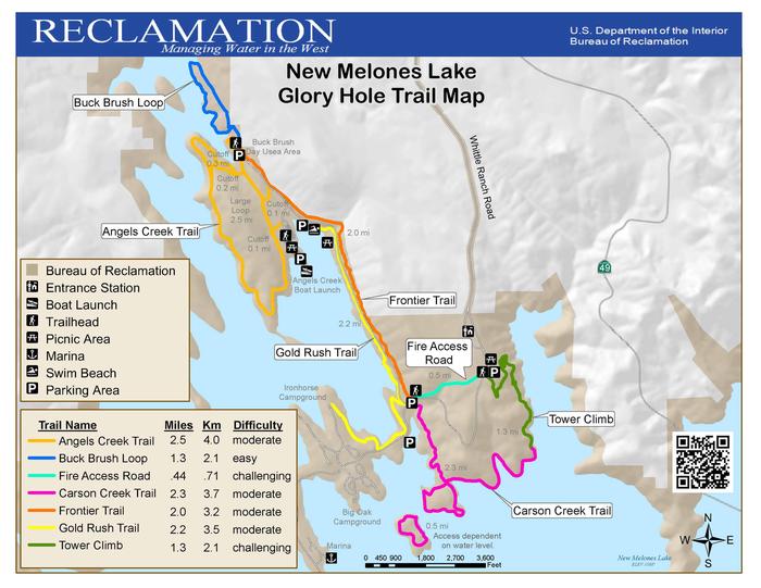
Visitors can experience the beauty of New Melones by hiking the many trails in the Tuttletown and Glory Hole Recreation Areas.
The climate is Mediterranean with warm, dry summers and cool, wet winters. For those who wish to venture outside the main recreation areas, there are many unique places to visit. Overall, the geography is quite varied and provides many opportunities for all types of recreation.
Nearby Attractions
Glory Hole Recreation Area is surrounded by many places of natural beauty including Natural Bridges, Camp Nine, Yosemite National Park, Stanislaus National Forest, Moaning Caverns, Big Trees State Park and Columbia State Park.
Angels Camp Museum, Calaveras County Museum and Sonora Military Museum also provide great opportunities for learning interesting information about the area.
Surrounding communities are popular vacation and retirement destinations and provide necessary services and shopping opportunities. Golfing, snow skiing, river rafting, commercial caves, historical railroad and Native American museums are close by as well.
Recreation
Hiking, fishing, wakeboarding, waterskiing, boating, sailing and road and mountain biking are just a few of the activities available in Glory Hole Recreation Area. Camping is also permitted in designated campsites. Equestrian trails are also present in the Peoria Wildlife Mitigation Area and open for the general public. Other interesting sites include Natural Bridges, which can be accessed from Parrott's Ferry Road and has a nice hiking trail and a creek that flows through a marble cave. The Table Mountain Trail provides visitors an opportunity to hike to the top of an extensive lava flow which occurred over nine million years ago.
Changes & Cancellations
All site changes and cancellations need to be done through the Recreation.gov website.
Contact Information
Mailing
GLORY HOLE RECREATION AREA, NEW MELONES LAKE 6850 Studhorse Flat Road Sonora CA 95370
Physical
GLORY HOLE RECREATION AREA 6503 Whittle Ranch Road Angels Camp CA 95222
Phone Number
For campground inquiries, please call: 209-536-9094
Rental Options
Learn more about gear rental options for your trip
Driving Directions
From Sacramento take 99 S, 88 W and 12 E to San Andreas. Take 49 S for approximately 15 miles. Turn right onto Whittle Ranch Road and follow the road 2 miles to the recreation area.
From Central California and the Bay Area take 80 E, 580 E then 205 E to 120 E in Manteca. Take the exit for 120 E/99 N. Continue on 120 E, then take 108 E to 49N. Turn left onto Whittle Ranch Road and follow the road 2 miles to the recreation area.
Available Campsites
- Site 023, Loop Ironhorse 1-7, 23-44, 60-69, Type Standard Nonelectric
- Site 068, Loop Ironhorse 1-7, 23-44, 60-69, Type Standard Nonelectric
- Site 132, Loop Big Oak 113-132, Type Rv Nonelectric
- Site 127, Loop Big Oak 113-132, Type Rv Nonelectric
- Site 114, Loop Big Oak 113-132, Type Rv Nonelectric
- Site 092, Loop Big Oak 90-112, Type Rv Nonelectric
- Site 075, Loop Ironhorse 8-22, 70-79, Type Walk To
- Site 009, Loop Ironhorse 8-22, 70-79, Type Standard Nonelectric
- Site 123, Loop Big Oak 113-132, Type Rv Nonelectric
- Site 126, Loop Big Oak 113-132, Type Rv Nonelectric
- Site 086, Loop Ironhorse 45-59, 80-89, Type Walk To
- Site 080, Loop Ironhorse 45-59, 80-89, Type Walk To
- Site 084, Loop Ironhorse 45-59, 80-89, Type Walk To
- Site 133, Loop Big Oak 133-144, Type Rv Nonelectric
- Site 122, Loop Big Oak 113-132, Type Rv Nonelectric
- Site 074, Loop Ironhorse 8-22, 70-79, Type Walk To
- Site 042, Loop Ironhorse 1-7, 23-44, 60-69, Type Standard Nonelectric
- Site 048, Loop Ironhorse 45-59, 80-89, Type Standard Nonelectric
- Site 098, Loop Big Oak 90-112, Type Rv Nonelectric
- Site 141, Loop Big Oak 133-144, Type Rv Nonelectric
- Site 060, Loop Ironhorse 1-7, 23-44, 60-69, Type Standard Nonelectric
- Site 003, Loop Ironhorse 1-7, 23-44, 60-69, Type Standard Nonelectric
- Site 016, Loop Ironhorse 8-22, 70-79, Type Standard Nonelectric
- Site 088, Loop Ironhorse 45-59, 80-89, Type Walk To
- Site 105, Loop Big Oak 90-112, Type Rv Nonelectric
- Site 128, Loop Big Oak 113-132, Type Rv Nonelectric
- Site 120, Loop Big Oak 113-132, Type Rv Nonelectric
- Site 043, Loop Ironhorse 1-7, 23-44, 60-69, Type Standard Nonelectric
- Site 108, Loop Big Oak 90-112, Type Rv Nonelectric
- Site 136, Loop Big Oak 133-144, Type Rv Nonelectric
- Site 089, Loop Ironhorse 45-59, 80-89, Type Walk To
- Site 066, Loop Ironhorse 1-7, 23-44, 60-69, Type Standard Nonelectric
- Site 134, Loop Big Oak 133-144, Type Rv Nonelectric
- Site 135, Loop Big Oak 133-144, Type Rv Nonelectric
- Site 013, Loop Ironhorse 8-22, 70-79, Type Standard Nonelectric
- Site 050, Loop Ironhorse 45-59, 80-89, Type Standard Nonelectric
- Site 006, Loop Ironhorse 1-7, 23-44, 60-69, Type Standard Nonelectric
- Site 110, Loop Big Oak 90-112, Type Rv Nonelectric
- Site 020, Loop Ironhorse 8-22, 70-79, Type Standard Nonelectric
- Site 139, Loop Big Oak 133-144, Type Rv Nonelectric
- Site 004, Loop Ironhorse 1-7, 23-44, 60-69, Type Standard Nonelectric
- Site 001, Loop Ironhorse 1-7, 23-44, 60-69, Type Standard Nonelectric
- Site 115, Loop Big Oak 113-132, Type Rv Nonelectric
- Site 053, Loop Ironhorse 45-59, 80-89, Type Standard Nonelectric
- Site 077, Loop Ironhorse 8-22, 70-79, Type Walk To
- Site 079, Loop Ironhorse 8-22, 70-79, Type Walk To
- Site 052, Loop Ironhorse 45-59, 80-89, Type Standard Nonelectric
- Site 107, Loop Big Oak 90-112, Type Rv Nonelectric
- Site 008, Loop Ironhorse 8-22, 70-79, Type Standard Nonelectric
- Site 137, Loop Big Oak 133-144, Type Rv Nonelectric
- Site 106, Loop Big Oak 90-112, Type Rv Nonelectric
- Site 094, Loop Big Oak 90-112, Type Rv Nonelectric
- Site 138, Loop Big Oak 133-144, Type Rv Nonelectric
- Site 047, Loop Ironhorse 45-59, 80-89, Type Standard Nonelectric
- Site 059, Loop Ironhorse 45-59, 80-89, Type Standard Nonelectric
- Site 078, Loop Ironhorse 8-22, 70-79, Type Walk To
- Site 072, Loop Ironhorse 8-22, 70-79, Type Walk To
- Site 021, Loop Ironhorse 8-22, 70-79, Type Standard Nonelectric
- Site 019, Loop Ironhorse 8-22, 70-79, Type Standard Nonelectric
- Site 057, Loop Ironhorse 45-59, 80-89, Type Standard Nonelectric
- Site 041, Loop Ironhorse 1-7, 23-44, 60-69, Type Standard Nonelectric
- Site 118, Loop Big Oak 113-132, Type Rv Nonelectric
- Site 097, Loop Big Oak 90-112, Type Rv Nonelectric
- Site 005, Loop Ironhorse 1-7, 23-44, 60-69, Type Standard Nonelectric
- Site 109, Loop Big Oak 90-112, Type Rv Nonelectric
- Site 099, Loop Big Oak 90-112, Type Rv Nonelectric
- Site 058, Loop Ironhorse 45-59, 80-89, Type Standard Nonelectric
- Site 119, Loop Big Oak 113-132, Type Rv Nonelectric
- Site 027, Loop Ironhorse 1-7, 23-44, 60-69, Type Standard Nonelectric
- Site 031, Loop Ironhorse 1-7, 23-44, 60-69, Type Standard Nonelectric
- Site 083, Loop Ironhorse 45-59, 80-89, Type Walk To
- Site 100, Loop Big Oak 90-112, Type Rv Nonelectric
- Site 070, Loop Ironhorse 8-22, 70-79, Type Walk To
- Site 081, Loop Ironhorse 45-59, 80-89, Type Walk To
- Site 035, Loop Ironhorse 1-7, 23-44, 60-69, Type Standard Nonelectric
- Site 049, Loop Ironhorse 45-59, 80-89, Type Standard Nonelectric
- Site 103, Loop Big Oak 90-112, Type Rv Nonelectric
- Site 116, Loop Big Oak 113-132, Type Rv Nonelectric
- Site 028, Loop Ironhorse 1-7, 23-44, 60-69, Type Standard Nonelectric
- Site 010, Loop Ironhorse 8-22, 70-79, Type Standard Nonelectric
- Site 143, Loop Big Oak 133-144, Type Rv Nonelectric
- Site 011, Loop Ironhorse 8-22, 70-79, Type Standard Nonelectric
- Site 002, Loop Ironhorse 1-7, 23-44, 60-69, Type Standard Nonelectric
- Site 093, Loop Big Oak 90-112, Type Rv Nonelectric
- Site 130, Loop Big Oak 113-132, Type Rv Nonelectric
- Site 090, Loop Big Oak 90-112, Type Rv Nonelectric
- Site 082, Loop Ironhorse 45-59, 80-89, Type Walk To
- Site 102, Loop Big Oak 90-112, Type Rv Nonelectric
- Site 095, Loop Big Oak 90-112, Type Rv Nonelectric
- Site 018, Loop Ironhorse 8-22, 70-79, Type Standard Nonelectric
- Site 007, Loop Ironhorse 1-7, 23-44, 60-69, Type Standard Nonelectric
- Site 030, Loop Ironhorse 1-7, 23-44, 60-69, Type Standard Nonelectric
- Site 104, Loop Big Oak 90-112, Type Rv Nonelectric
- Site 117, Loop Big Oak 113-132, Type Rv Nonelectric
- Site 039, Loop Ironhorse 1-7, 23-44, 60-69, Type Standard Nonelectric
- Site 032, Loop Ironhorse 1-7, 23-44, 60-69, Type Standard Nonelectric
- Site 036, Loop Ironhorse 1-7, 23-44, 60-69, Type Standard Nonelectric
- Site 040, Loop Ironhorse 1-7, 23-44, 60-69, Type Standard Nonelectric
- Site 046, Loop Ironhorse 45-59, 80-89, Type Standard Nonelectric
- Site 045, Loop Ironhorse 45-59, 80-89, Type Standard Nonelectric
- Site 062, Loop Ironhorse 1-7, 23-44, 60-69, Type Standard Nonelectric
- Site 067, Loop Ironhorse 1-7, 23-44, 60-69, Type Standard Nonelectric
- Site 034, Loop Ironhorse 1-7, 23-44, 60-69, Type Standard Nonelectric
- Site 025, Loop Ironhorse 1-7, 23-44, 60-69, Type Standard Nonelectric
- Site 033, Loop Ironhorse 1-7, 23-44, 60-69, Type Standard Nonelectric
- Site 087, Loop Ironhorse 45-59, 80-89, Type Walk To
- Site 063, Loop Ironhorse 1-7, 23-44, 60-69, Type Standard Nonelectric
- Site 014, Loop Ironhorse 8-22, 70-79, Type Standard Nonelectric
- Site 054, Loop Ironhorse 45-59, 80-89, Type Standard Nonelectric
- Site 142, Loop Big Oak 133-144, Type Rv Nonelectric
- Site 017, Loop Ironhorse 8-22, 70-79, Type Standard Nonelectric
- Site 096, Loop Big Oak 90-112, Type Rv Nonelectric
- Site 038, Loop Ironhorse 1-7, 23-44, 60-69, Type Standard Nonelectric
- Site 037, Loop Ironhorse 1-7, 23-44, 60-69, Type Standard Nonelectric
- Site 101, Loop Big Oak 90-112, Type Rv Nonelectric
- Site 022, Loop Ironhorse 8-22, 70-79, Type Standard Nonelectric
- Site 029, Loop Ironhorse 1-7, 23-44, 60-69, Type Standard Nonelectric
- Site 125, Loop Big Oak 113-132, Type Rv Nonelectric
- Site 140, Loop Big Oak 133-144, Type Rv Nonelectric
- Site 056, Loop Ironhorse 45-59, 80-89, Type Standard Nonelectric
- Site 085, Loop Ironhorse 45-59, 80-89, Type Walk To
- Site 073, Loop Ironhorse 8-22, 70-79, Type Walk To
- Site 121, Loop Big Oak 113-132, Type Rv Nonelectric
- Site 071, Loop Ironhorse 8-22, 70-79, Type Walk To
- Site 015, Loop Ironhorse 8-22, 70-79, Type Standard Nonelectric
- Site 065, Loop Ironhorse 1-7, 23-44, 60-69, Type Standard Nonelectric
- Site 091, Loop Big Oak 90-112, Type Rv Nonelectric
- Site 026, Loop Ironhorse 1-7, 23-44, 60-69, Type Standard Nonelectric
- Site 044, Loop Ironhorse 1-7, 23-44, 60-69, Type Standard Nonelectric
- Site 051, Loop Ironhorse 45-59, 80-89, Type Standard Nonelectric
- Site 024, Loop Ironhorse 1-7, 23-44, 60-69, Type Standard Nonelectric
- Site 055, Loop Ironhorse 45-59, 80-89, Type Standard Nonelectric
- Site 076, Loop Ironhorse 8-22, 70-79, Type Walk To
- Site 069, Loop Ironhorse 1-7, 23-44, 60-69, Type Standard Nonelectric
- Site 061, Loop Ironhorse 1-7, 23-44, 60-69, Type Standard Nonelectric
- Site 012, Loop Ironhorse 8-22, 70-79, Type Standard Nonelectric
- Site 064, Loop Ironhorse 1-7, 23-44, 60-69, Type Standard Nonelectric
- Site 129, Loop Big Oak 113-132, Type Rv Nonelectric
- Site 111, Loop Big Oak 90-112, Type Rv Nonelectric
- Site 112, Loop Big Oak 90-112, Type Rv Nonelectric
- Site 124, Loop Big Oak 113-132, Type Rv Nonelectric
- Site 113, Loop Big Oak 113-132, Type Rv Nonelectric
- Site 144, Loop Big Oak 133-144, Type Rv Nonelectric
- Site 131, Loop Big Oak 113-132, Type Rv Nonelectric