Aransas National Wildlife Refuge
Fish and Wildlife Service, Texas.
What is today known as Aransas National Wildlife Refuge first emerged 120,000 years ago during the Pleistocene era when a barrier island was born. The Pleistocene era passed into geological history; behind it was left the land and a few mementos of that era, including fossilized teeth and alligators.
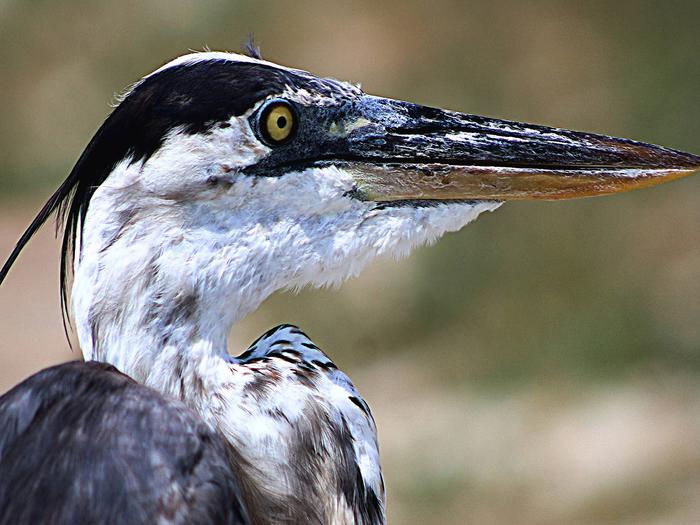
Today, this landscape is best known for its prominent place in the American wildlife conservation movement. In 1941, when only 15 whooping cranes survived in the wild, the iconic bird became an emblem of alarm and concern for all endangered and threatened species. Aransas became a focal point of the national and worldwide effort to rescue the species from extinction.
Thankfully, due to the foresight of others, the Aransas National Wildlife Refuge was established in 1937 to serve as a refuge and breeding ground for migratory birds and other wildlife and as an inviolate sanctuary, or for any other management purpose, for migratory birds. The Matagorda Island Unit of the refuge is a 56,683-acre natural area that was established to support the national migratory bird management program and to conserve endangered species. The island has no public means of access. Its isolation provides an unparalleled opportunity for protection of its bountiful natural resources.
Nearby Activities
- Biking
- Birding
- Fishing
- Hiking
- Hunting
- Wildlife Viewing
Directions
From the South: Follow Highway 35N to the FM 774 exit. Turn right on FM 774 and go approximately 6 miles, winding through the farm fields. Turn right again on FM 2040. Drive another 6 miles to the Refuge gate. Go to the Visitor Contact Station to register.
From the North: Travel south on Hwy 35 to Tivoli. Continue past Tivoli approximately 1 mile to the FM 239 exit (on your left). Follow FM 239 to Austwell. Upon entering Austwell, FM 239 turns into FM 774 at the curve. Continue on FM 774. Follow 774 and take a right at the stop sign. At the end of the street, take a right again. As you exit Austwell, drive ½ mile to the FM 2040 intersection. Turn left on FM 2040 and drive 6 miles to the Refuge gate. Go to the Visitor Contact Station to register.
The GPS coordinates for the refuge’s main entrance are: 28.313449,-96.804022.