Necedah National Wildlife Refuge
Fish and Wildlife Service, Wisconsin.
The prehistoric lands that make up Necedah National Wildlife Refuge sat at the bottom of Glacial Lake Wisconsin more than 18,000 years ago. Flowing glacial rivers fed the vast lake depositing sand and silt in ribbons across the lake bottom. Fast-forward through time as the glacial runoff changed course drastically from a northwest flow that moved toward the Black River, changing to a southeast exodus and flood. Water cascaded through breached moraines and fractured, glacial ice dams helping form some of the cut sandstone gorges near Wisconsin Dells. Catastrophic draining of the lake’s water exposed sand deposits and the washed topography of the lake bottom. Those sand deposits and scours formed the mosaic of dry ridges and wetland braids that now create Necedah National Wildlife Refuge.
The shallow water table that remained gave rise to a vast complex of peat bogs and sedge meadows edged with tamarack and interlaced with upland forests, savannas and prairies along the remnant sand ridges. Elk and bison roamed through the refuge as prairie chickens and passenger pigeons made their homes here as well. Vast wildfires reset vegetation communities periodically across large expanses of what we now know as Wisconsin.
By the 1700s, human interactions increased with the land that we know now as Necedah National Wildlife Refuge. Humans living on the landscape tried to mimicked nature with fire and water to gather food, raise plants for harvest while living a nomadic lifestyle alongside wildlife. As more people arrived in the 1800s and started to put down roots year round. They devised ways to try to control the water and use the resources around them. Logging operations started and row crops were planted to support settlements and domestic animals.
Nature’s pendulum continued to swing between dry and wet periods. Dried out peat burned relentlessly and cleared the way for more crops. As the drought subsided in the late 1800s the area became increasingly wet, with relentless water refilling the basin during what was known as the drainage dream. The refuge and the surrounding area was now also known as The Great Wisconsin Swamp. Nature’s pendulum swung back again as the dust bowl era began.
The Great Wisconsin Swamp was now the most indebted drainage district in the state. Resulting in forfeited farms, homesteads and lands by the early 1920s. Resettlement and relocations continued as the Civilian Conservation Corps started restoring the land to semi-natural conditions by creating dams in the former drainage ditches.
Restoring water back on an area that had been logged, burned, drained, farmed and then abandoned became the site for a new era. Remaining families in the area like the Rynearsons and the Hamerstroms, students of Aldo Leopold, envisioned a new dream for the Great Central Wisconsin Swamp. A vision where wildlife would be the primary residents.
At the same time, conservation dreams for the area were forming as President Franklin D. Roosevelt was working to restore wild spaces for game and migratory birds. The culmination of the Civilian Conservation Corps, Rynearsons, Hamerstroms, Leopold and President F.D.R. efforts became the Necedah Migratory Bird Refuge, now known as Necedah National Wildlife Refuge, on March 14, 1939. This federal designation was the catalyst for the landscape legacy of conserving resident wildlife, game and migratory birds through wildlife management, monitoring, research and adaptive conservation methods on 110,000 acres of federal lands.
Habitat management, water control and wildlife plantings dominated the work on the refuge after establishment. The Civilian Conservation Corps also helped establish the legacy of public use and enjoyment of the refuge with the building of the observation tower in Rynearson Pool 1. Fast-forward one more time to present day, where a team of managers, biologists, equipment operators, fire staff, law enforcement and visitor services specialists all continue to work with wildlife, their habitats and people to conserve and enjoy our natural resources.
The refuge is recognized as an official Important Bird Area internationally by BirdLife International and the United States National Audubon Society. These areas provide essential habitat to one or more bird species of conservation concern that are threatened or endangered, which are vulnerable species that are not widely distributed or concentrated in one general habitat type, and species that are vulnerable because they congregate together for breeding, feeding or migration.
Suk Cerney Flowage is recognized as a Wisconsin Wetland Gem by the Wisconsin Wetlands Association for its ecological importance and high quality wetland diversity. The accompanying upland community types that surrounding wetlands like these also represent a fully functioning ecological system.
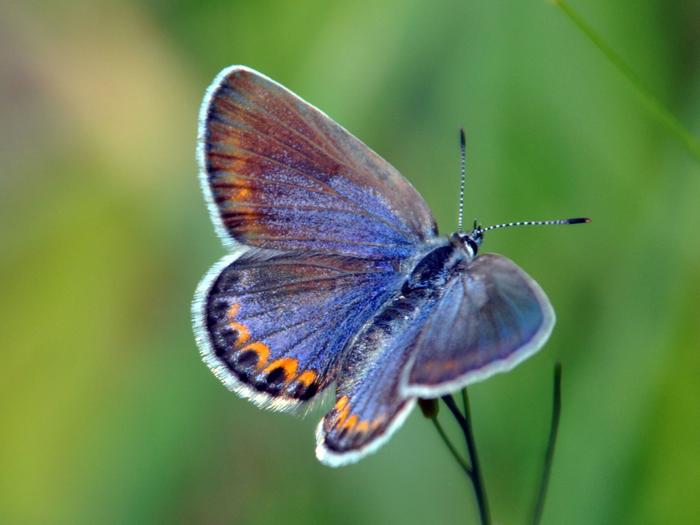
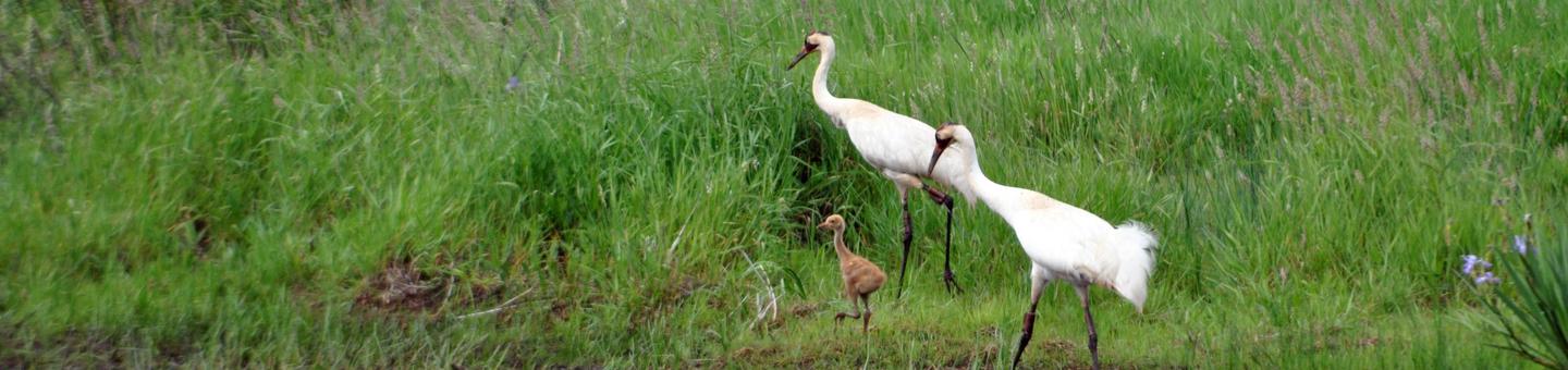
The refuge is home to more than 230 bird species, black bears, gray wolves, American badgers, Boghaunter dragonflies, Blanding’s turtles and many more common to endangered plants and animals. We work to promote the recovery of whooping cranes, Karner blue butterflies and Kirtland’s warblers and have been named Endangered Species Recovery Champions for these efforts and for hosting the largest wetland complex in the state, as well as the largest population of Karner blue butterflies in the country.
The refuge, as a whole, and its trails are part of the Great Wisconsin Birding and Nature Trail. These sites and trails around Wisconsin showcase a commitment to environmental stewardship and offer areas for the public to observe the fascinating diversity nature holds and the wildlife that call Wisconsin home.
Nearby Activities
- Archery
- Auto Touring
- Birding
- Boating
- Cross Country Skiing
- Fishing
- Hiking
- Hunting
- Interpretive Programs
- Motor Boat
- Non-Motorized Boating
- Photography
- Snowshoeing
- Wildlife Viewing
Directions
The refuge entrance is located off of Hwy 21, four miles west of Necedah, Wisconsin or 18 miles east of Tomah, Wisconsin. To reach the visitor center, turn onto Headquarters Road and travel two miles north into the interior of the refuge.
Navigation Note: There are many township roads that crisscross the 40,000 acres of refuge, not all are passable. This sometimes confuses navigation apps. The visitor center is located at N11385 Headquarters Road, Necedah, Wisconsin 54646. Please be sure you are routed from Hwy 21 onto Headquarters Road. Many local seasonal roads are dead ends.
The refuge is located 150 miles from Milwaukee, Wisconsin and 180 miles from Minneapolis, Minnesota. Most of the refuge lies north of Highway 21 and west of Highway 80, with all property in Juneau County.