Warner Wetlands
Bureau of Land Management, Oregon.
Overview:
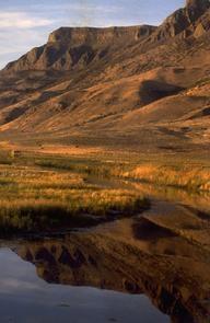
Formed thousands of years ago when gigantic faults in the earth’s crust shifted, today’s Warner Wetlands is a 40-mile chain of lakes separated by a unique series of bow-shaped dunes. Each spring and fall, thousands of birds visit the wetlands during their annual migrations. Recreation facilities include the Hart Bar Interpretive Site, Warner Valley Overlook, and the Warner Valley Canoe Trail. The interpretive site has restrooms, a sheltered picnic table, interpretive panels, and a 0.25 mile hiking trail to wildlife viewing blinds. The Warner Valley Overlook affords a panoramic overview of the wetlands with the desert buttes to the west and south.Know Before You Go:
Numerous recreational opportunities exist onsite for bird watching, hunting, fishing, camping, and boating; however, most of these activities are dependent on the water levels of the lakes which can fluctuate dramatically. Contact the BLM Lakeview District office to receive updated information about current lake levels before planning a trip to the Warner Wetlands.Point of Interest:
During wet years, the ten-mile Warner Valley Canoe Trail is open for experienced paddlers is marked and marked in the channels between Campbell, Turpin, and Stone Corral Lakes.Nearby Activities
- Auto Touring
- Camping
- Fishing
- Hunting
- Interpretive Programs
- Off Highway Vehicle
- Picnicking
- Wildlife Viewing
Directions
From Lakeview, Oregon, travel north on U.S. Highway 395 for six miles, and turn east on Highway 140 for approximately 14 miles to County Road 3-13, known locally as the Plush Cutoff Road. Travel on this road for 15 miles to Plush, Oregon. From Plush, travel north for 0.8 miles, and turn east on County Road 3-12. Drive approximately four miles to the Hart Bar Interpretive Site, located at the base of Hart Mountain.