Simon Canyon Area of Critical Environmental Concern
Bureau of Land Management, New Mexico.
Simon Canyon Area of Critical Environmental Concern (ACEC) is about 3,900 acres in size and is managed for semi-primitive forms of recreation including fishing, hiking, and backpacking. Development at the mouth of the canyon is minimal (with a parking lot, picnic table, and toilet) and provides the visitor an alternative to the more highly developed state park sites located nearby.
The sandstone canyon is characterized by moderately steep, to very steep, rough and broken terrain. Vegetation in the area is varied and ranges from shrubs, cactus species and cottonwood trees found at the canyon bottom, to piсon and juniper trees at upper elevations, with small scattered patches of Ponderosa pine and Douglas fir along the high canyon rim. Water from the small intermittent stream that flows down the canyon provides for areas of riparian plant communities.
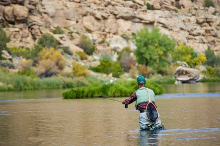
The diverse canyon landscape provides habitat for a variety of bird and mammal species such as the golden eagle, prairie falcon, great horned owl, porcupine, beaver, and deer. Local sportsmen and fishing enthusiasts from across the United States come to fish the Quality Waters of the San Juan River, including the stretch that flows past the mouth of Simon Canyon. Narrow trails winding along the river's edge will lead you to your favorite fishing spot.
The canyon also contains remnants of an earlier human occupation. Simon Canyon Ruin, a Navajo Pueblito, sits on a bench overlooking the canyon drainage. It is the only classic "boulder type" defensive site built north of the San Juan River and dates back to 1754. It consists of a well-preserved one-room structure built on top of a large boulder. Simon Ruin can be reached by taking a short hike up a steep dirt road past an active well location, then continuing on a foot path located along the bench overlooking the canyon drainage.
Nearby Activities
- Camping
- Fishing
- Hiking
- Historic & Cultural Site
- Picnicking
- Wildlife Viewing
Directions
Simon Canyon ACEC is north of the San Juan River, about 3 miles west of Navajo Reservoir. It is about 20 miles east of Aztec and Bloomfield, NM, and is generally accessible via US Highways 550 and 64 and State roads 173, 511, and 539. It can also be reached from the Colorado Stateline by taking NM 511 and NM 173. To reach the parking lot, turn north from NM 173 onto non-maintained County Road 4280. Follow the road about 3 miles from the turnoff to reach the parking lot.
Additional Information
- BLM New Mexico Twitter
- BLM New Mexico Facebook Page
- BLM New Mexico YouTube Channel
- BLM New Mexico Twitter
- BLM New Mexico Flickr
- BLM New Mexico Facebook Page
- BLM New Mexico Flickr
- Simon Canyon Area of Critical Environmental Concern Map
- Simon Canyon Area of Critical Environmental Concern
- Simon Canyon ACEC
- BLM New Mexico YouTube Channel