Bosque Del Apache National Wildlife Refuge
Fish and Wildlife Service, New Mexico.
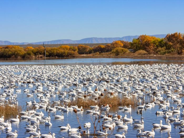
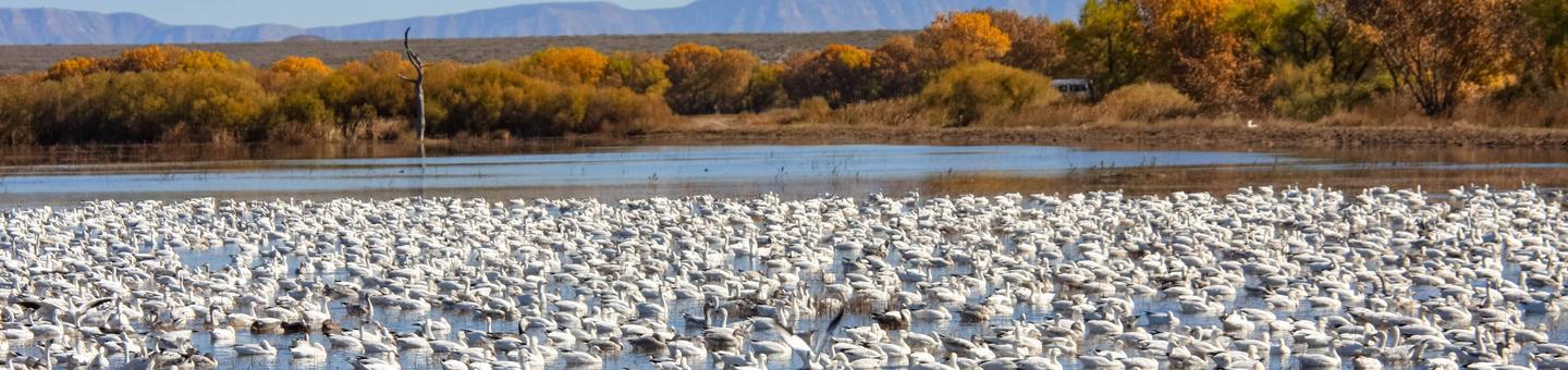
Bosque del Apache National Wildlife Refuge, located in San Antonio, Socorro County, New Mexico, is one of over 560 units within the National Wildlife Refuge System. Situated between the Chupadera Mountains to the west and the San Pascual Mountains to the east, the 57,331 acre Bosque del Apache was established in 1939 to provide a critical stopover site for migrating waterfowl. The refuge is well known for the tens of thousands of cranes, geese, and ducks who winter here each year. Over 30,000 acres of Bosque del Apache are designated wilderness.
The Rio Grande may seem tame now, but for thousands of years it was a wild and unpredictable river. Every spring, melting snow from the mountains filled the river with water until it overflowed its banks – flooding the land around it.
In the summer, heavy rains swelled the river even more. At times, the overflowing water was so powerful that the entire path of the river changed, forming new ponds and marshes in the old riverbed. In these fertile river floodplains, all kinds of lush vegetation grew – providing plentiful food sources for wildlife. Majestic birds like sandhill cranes migrated here to spend the winter feasting on nutritious grasses like chufa and millet while other animals thrived amid the cottonwood forests and shrublands.
The big river attracted humans too. More than 700 years ago, Piro Indians built settlements of mud and stone houses along the river. They hunted and gathered food along the riverbanks, and they learned to farm the bottomlands.
In the late 16th century, Spanish colonists arrived following the river northward. Their horses, wagons, cattle, and sheep trampled a rutted, dusty road. As more people moved in, they created ranches, farms, and towns that replaced the Piro Indians and their pueblos.
The new settlers started to change the Rio Grande. A river that overflowed and dug new routes every season was seen as a problem – especially if your house got flooded or your crops washed away. So, people started building dams and irrigation ditches to manage the flow of the river and divert water for crops, livestock, and homes. Taming the wild Rio Grande was great for people – but not great for wildlife. The once-grand river shrank to a shallow stream.
Without a flooding river, the floodplain marshes dried up. Chufa, millet, and other plants that grew in the wetlands started to disappear. When their food supply disappeared, the region’s wildlife – especially its migratory birds – started to disappear too.
Yet, many people thought the wildlife and habitats along this portion of the river were worth preserving. In the 1930s, the Civilian Conservation Corps began working to restore the floodplains in the Bosque del Apache area as wildlife habitat. In 1939, President Franklin Delano Roosevelt established Bosque del Apache National Wildlife Refuge as part of a national system of lands dedicated to wildlife protection.
Today, our staff manages water to create wetlands like when the river ran wild. These seasonal wetlands re-create the types of habitats that both year-round and migratory wildlife need to thrive. Using gates and ditches, water is moved from the river through fields, marshes, and ponds, and then back to the river to mimic natural flooding cycles.
Once again, the Rio Grande and its wetlands provide food and homes for some of America’s most spectacular wildlife, as well as places where thousands of people can observe and enjoy the natural world.
Bosque del Apache Wilderness
Designated in 1975
30,427 acres
The Wilderness Act of 1964 created the National Wilderness Preservation System "in order to assure that an increasing population, accompanied by expanding settlement and growing mechanization, does not occupy and modify all areas in the United States, and its possession, leaving no lands designated for preservation and protection in their natural condition..."
For more information about Bosque del Apache wilderness, visit wilderness.net.
Nearby Activities
- Auto Touring
- Biking
- Birding
- Educational Programs
- Environmental Education
- Fishing
- Hiking
- Hunting
- Interpretive Programs
- Photography
- Picnicking
- Visitor Center
- Wildlife Viewing
Directions
The Visitor Center is located at 1001 NM-1, San Antonio, New Mexico; the coordinates for the Visitor Center are 33.804777, -106.890917
From points north (Socorro, Albuquerque, Santa Fe): drive south on Interstate 25 to exit 139 (San Antonio), go east 0.25 miles on US 380 to the flashing signal at the village of San Antonio, turn south (right) onto Highway 1, and drive south to the Visitor Center (on right).
From points south (Truth or Consequences, Las Cruces): drive north on Interstate 25 to exit 115, then north on Highway 1 to the Visitor Center (on left).
From points east (Carrizozo, Roswell): drive west on US 380 to the town of San Antonio. At the flashing signal at the village of San Antonio, turn south (left) onto Highway 1, and drive south to the Visitor Center (on right).
From points west (Quemado, Springerville): drive east on Highway 60 to the town of Socorro, then right on Main Street toward Interstate 25. Merge onto south-bound Interstate 25 to exit 139 (San Antonio), go east 0.25 miles on US 380 to the flashing signal at the village of San Antonio, turn south (right) onto Highway 1, and drive south to the Visitor Center (on right).