Rawhide Mountains Wilderness
Bureau of Land Management, Arizona.
The Rawhide Mountains Wilderness in Arizona is managed by the Bureau of Land Management. In 1990, the Rawhide Mountains Wilderness became part of the now over 109 million acre National Wilderness Preservation System established by the Wilderness Act of 1964.The 38,470-acre Rawhide Mountains Wilderness is located in Mohave and La Paz Counties 80 miles south of Kingman, Arizona and 50 miles southeast of Lake Havasu City, Arizona.
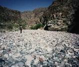
The wilderness includes portions of two mountain ranges, the Rawhide Mountains to the north and the Buckskins to the south, separated by eight miles of the Bill Williams River. More than five miles of this perennial stream meander through a 600-foot-deep gorge, and several rocky side canyons with small waterfalls enter the main canyon within the wilderness. The riparian environment here supports a variety of plants and animals, including a cottonwood-willow plant community, beavers, raptors, amphibians and reptiles. This area also provides habitat for a pair of nesting bald eagles.
The Rawhide Mountains are low hills punctuated by numerous rugged outcrops. These hills rise from 700 feet to an elevation of 2,430 feet. The mountains are cut by several washes and canyons, most notably the Mississippi Wash, which winds down a narrow canyon with several small waterfalls. The Buckskin Mountains rise from 1,700 feet in Butler Valley to the 3,927-foot high Ives Peak. The large size of this wilderness, the varied and colorful terrain, and the presence of year-round water enhance wilderness opportunities for hikers, backpackers, river-runners, birdwatchers and photographers. In wilderness, you can enjoy challenging recreational activities and extraordinary opportunities for solitude.
Please follow the regulations in place for this area, and use Leave No Trace techniques when visiting to ensure protection of its unique natural and experiential qualities.
Motorized equipment and equipment used for mechanical transport are generally prohibited on all federal lands designated as wilderness. This includes the use of motor vehicles (including OHVs), motorboats, bicycles, hang gliders, wagons, carts, portage wheels, and the landing of aircraft including helicopters Contact the agency for more information about regulations.
Some lands around the wilderness are not federally administered. Please respect the property rights of the owners and do not cross or use these lands without their permission.
Nearby Activities
- Hiking
- Horseback Riding
- Wilderness
- Wildlife Viewing
Directions
The Bill Williams River gorge, located downstream from Alamo Dam, is accessible from Alamo Lake State Park, along the south shore of Alamo Lake. Parking is available at the dam overlook. It is 1.5 miles from the overlook to the bottom of the dam where the gorge begins. The gorge may be closed to hikers during the late winter and spring months to lessen disturbance to nesting bald eagles.
That portion of the wilderness located north of the Bill Williams River can be accessed via county-maintained Alamo Road. Alamo Road can be accessed from Yucca, Arizona, 22 miles south of Kingman on Interstate 40, or from Wikieup, Arizona, on U.S.Highway 93 via the county-maintained Chicken Springs Road.