Santa Rosa Wilderness
Bureau of Land Management, California.
Overview
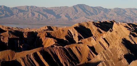
The terrain within the Santa Rosa Mountains Wilderness is rugged with elevations rising dramatically from just above sea level to 7,000 feet. Laced with deep washes and shallow drainages, the area supports a variety of riparian streams which flow year-round. Here, desert and mountain environments blend together to form unique plant habitats, which thrive in riparian oases. The Santa Rosas are strewn with boulders. The steep canyon walls have been eroded by springs and streams.
Bear Creek Oasis, Lost Canyon Oasis, Guadelupe Canyon, Devil Canyon and Rockhouse Canyon are all found within this wilderness. Many of these areas provide important lambing habitat for bighorn sheep. The Santa Rosa Mountains support the largest herd of Peninsular bighorn sheep in the United States. Mule deer can be found throughout the coniferous forests, which grow along the higher elevations of the range. Great horned owls, prairie falcons and golden eagles nest and forage throughout the entire wilderness. Reptiles, including frogs, toads and the desert slender salamander also live in this desert setting.
History
 The Santa Rosa Mountains have been the homeland of hundreds of generations of Cahuilla, whose culture has been described and recorded in numerous publications. Direct evidence links the tribe to this area for at least 3,000 years. Within the Santa Rosas are sacred sites, such as the peak of the Santa Rosa Mountain and Tahquitz Peak, and landscape features which are of great importance to Cahuilla history.
Within the mountain range, Cahulla villages were generally located in or near the mouth of a canyon or in a valley, and in some instances there were both summer and winter villages with the former being at higher elevations and the latter closer to the valley floor. A network of trails connect village sites, campsites, and other areas of importance. Cahuilla lived in the Santa Rosas until the late 19th century, by which time most Cahuilla had moved to nearby reservations or the Coachella Valley, and contemporary Cahuilla have strong feelings and concern for their ancestral homeland.
he Santa Rosas have great heritage value to the Cahuilla and many sites are of National Register quality. The linked document contains descriptions of some of the more significant prehistoric and historic sites in the Santa Rosa Mountains.
Nearby Activities
- Camping
- Hiking
- Historic & Cultural Site
- Horseback Riding
- Hunting
- Photography
- Wilderness
- Wildlife Viewing
Directions
Riverside County; 7 miles south of Palm Springs, California. State Highway 74 provides access to the Santa Rosa Mountains from the north; State Highway 86 and surface streets provide access from the east.