Ledgefork
LEDGEFORK
Part of Uinta-Wasatch-Cache National Forest
Overview
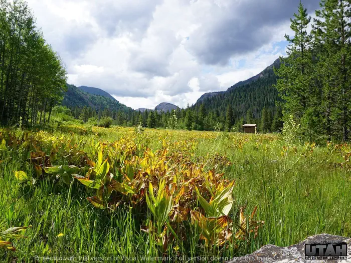
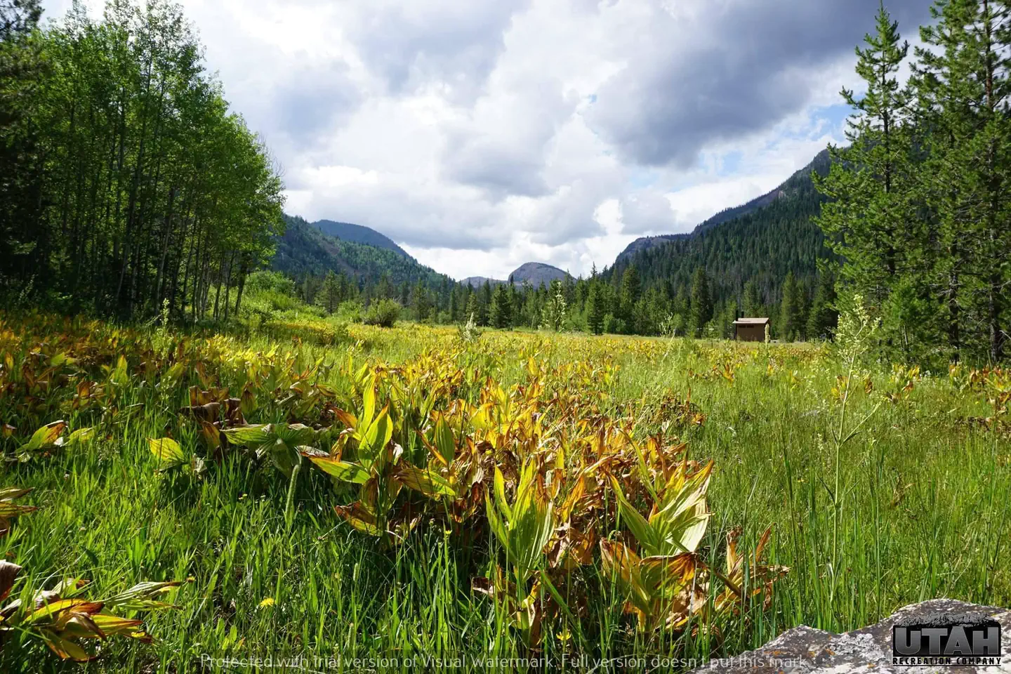
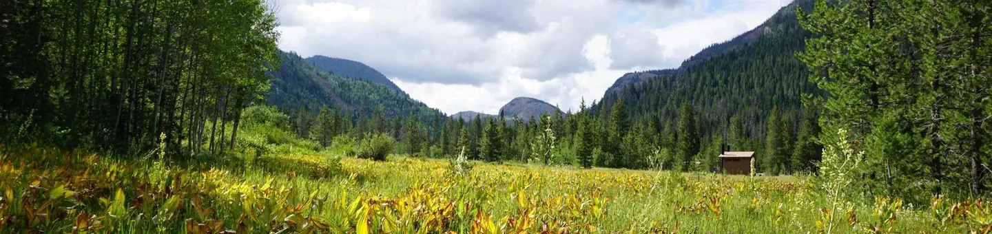
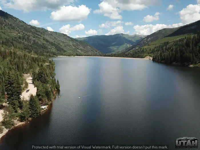
Ledgefork Campground is located just above Smith and Morehouse Reservoir on the western edge of the Uinta Mountains in northeastern Utah. The town of Oakley is just 14 miles away. Visitors enjoy fishing, canoeing and exploring the Smith and Morehouse Trail.Facilities
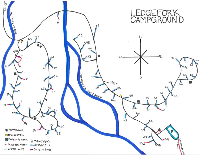
The campground contains several single and double sites with picnic tables and campfire rings. Vault toilets are provided. Firewood is available for purchase from the host.
Natural Features
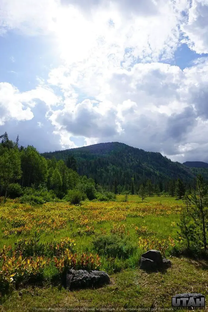
The campground is situated within a quarter-mile of the reservoir in a scenic conifer and aspen forest at an elevation of 7,800 feet. Smith and Morehouse Creek runs through the campground. A variety of wildlife makes its home around the reservoir, including moose and deer. Summer temperatures range from 65-75 degrees in the day to 40-50 at night.Recreation
The reservoir is open to motorized boats, though a wake-less speed is enforced, making it an excellent place for canoeing and kayaking. A boat ramp is located on the northwest shore. Anglers enjoy fishing for stocked rainbow trout and other native fish species.
The 12-mile round-trip Smith and Morehouse Trail is popular with hikers and backpackers. The trail begins in the campground and leads through forests, meadows and a marsh before spurring off to Erickson Basin and Island Lake.
Contact Info
For facility specific information, please call (385) 273-1100.Important Notices
This Campground is in Bear Country
Always store food and trash securely to avoid attracting wildlife
-Failure to comply may result in fines up to $5,000, removal from your site and/or imprisonment
Remember, a fed bear is a dead bear; your actions can save lives
There is no water available on site; bring all water needed for your stay including drinking water
This is a 'pack it in, pack it out' facility; bring trash bags
Save your waste water for dousing your fire.
Dogs or Domestic Pets
Owners must
-Control dogs by a leash not to exceed six feet (6’) at all times
-Clean up dog feces immediately
-Limit two dogs per site
Do not allow dogs to
-Threaten or attack people/animals
-Interfere with people, vehicles, or property
-Cause damage to vegetation or harass wildlife
Campground Etiquette and Rules
Gates open at 7am, Gates close at 10pm
Quiet Hours are 10pm-6am No generators after 10pm
Camping is allowed only within the designated space provided. Do not go beyond the boundaries of your site
Max occupancy is 8 people per single site
Reserved sites will be held until 12pm on the day following your scheduled arrival date
Horses/Off-road vehicles are prohibited in the campground
Leave No Trace
Put all trash in dumpsters, if provided, or properly stored in your vehicle or bear box
Remove all personal property and trash when leaving
Unclean sites will be reported to the District Ranger LEO
Leaving food/trash in an unoccupied site may result in a $5,000 fine
Cleaning fish, animals, or bathing where drinking water is supplied is strictly prohibited
Fireworks or other explosives are prohibited. Discharging of a firearm in the campground is not allowed
No boisterous behavior. Be courteous. Keep noise at a reasonable level
No amplified music is allowed in USDA Forest Service campgrounds and facilities
Max Vehicle Length includes tow vehicle
There is a 2-night minimum stay on weekends; 3-night minimum stay on holiday weekends
First Come First Served (FF) sites
For reservable sites, reservations must be made at least 5 days in advance
You must claim a FF site in person on the day you wish to check-in
A site listed as FF does not guarantee availability, Recreation.gov does not update FF occupancy
The only way to know if an FF site is available is to arrive at the campground on the day you plan to check-in
Availability cannot be predicted
Many sites are in remote locations, we cannot contact hosts about availability
Recommended arrival times vary by day. Weekends and holidays typically fill more quickly
To claim an FF site, you must be present, occupy the site, and pay at that time
Trailers/Campers and RVs: Come with water tank filled. Hooking up to spigots or the power in the restrooms, even for medical devices is strictly prohibited
Extra Vehicle -$10 per vehicle, per day (paid on-site cash/check)
Firewood -$9
If you booked at a discount without a Senior/Access pass, you'll need to pay the difference in cash/check upon arrival. Only Senior/Access passes qualify for discounts and proof of ownership upon arrival is required
Please understand that camping is an outdoor experience; we do not give refunds for weather or natural conditions
Cancellations within 24 hours prior to arrival date will forfeit the entire use fee and a $10 cancellation fee
No-shows, early departures, or cancellations after the arrival date are not entitled to a refund
Failure to arrive at the site by12pm the day after scheduled arrival and does not cancel the reservation, will be charged a $20 service fee and forfeit the first-night use fee
For more information on visiting Bear Country visit
For campground Rules and Regulations visit gocamputah.com/rules
Click herefor more info about the Uinta-Wasatch-Cache National Forest
For more info, please call Kamas Ranger District at 435-783-4338 or Utah Recreation at 385-273-1100
Visit our website gocamputah.comor Facebook facebook.com/letsgocamputah
To reserve a site call Recreation.gov reservation line 1-877-444-6777
Don't Move Firewood: Help prevent the spread of tree-killing pests in our national forests by obtaining firewood within 10 miles of your destination and burning it on-site. For more info visit click here
Please note: Utah Recreation is not responsible for accident or injury to any person or property resulting from the use of this facility and is not responsible for the loss of money or valuables of any kind. The user of this permit assumes full and complete responsibility for the conduct and actions of all members in their party
Available Activities
- Hiking - Hiking
- Fishing - Fishing
- Camping - Camping
- Canoeing - Canoeing
- Kayaking - Kayaking
- Swimming - Swimming
- Wildlife Viewing - Wildlife Viewing
- Boating - Boating
Directions
From Salt Lake City: From I 15, take I 80E past Park City to either Hwy 189 or Wanship. On 189, travel SE to Kearns Blvd/SR 248. Continue east on SR 248 to Browns Canyon Rd. Travel E/NE on Browns Canyon until it connects with SR 32 just north of Peoa. Turn south onto SR32 and travel until it becomes North Bench and then Weber Canyon Rd. From Wanship, take SR 32 past Rockport State Park to Peoa. At Peoa, SR32 becomes North Bench Rd and then Weber Canyon Rd. Stay on Weber Canyon Rd to FR 33. Turn right (south) onto FR 33 and travel past Smith Morehouse Reservoir to Ledgefork. (FR33 distance ~16 miles) <p> From Utah County (Provo): Follow US 189 (University Ave.) through Provo Canyon to Heber City. At the junction in Heber, turn left and stay on 189 going north until you reach SR32. Turn right (east) on SR32 and travel past Jordanelle State Park to Francis. At Francis, turn left (north) onto Main St. Stay on Main st. until it becomes New Lane Rd in Oakley. Stay on New Lane Rd to Weber Canyon Rs. Turn right (east) onto Weber Canyon Rd. Stay on Weber Canyon Rd to FR 33. Turn right (south) onto FR 33 and travel past Smith Morehouse Reservoir to Ledgefork. (FR33 distance ~16 miles) </p>
Cancellation Policy
<p><strong>Change and Cancellation Policies and Fees</strong></p> <ul> <li>Overnight and Day Use Facilities: To ensure fairness, reservation arrival or departure dates may not be changed beyond the booking window until 18 days after booking the reservation.</li> <li>Camping / Day Use: A $10.00 service fee will apply if you change or cancel your reservation (including campsites, cabins, lookouts, group facilities, etc.). The $10.00 service fee will be deducted from the refund amount.</li> <li>You can cancel or change reservations through Recreation.gov or by calling 1-877-444-6777.</li> </ul> <p><strong>Late Cancellations</strong></p> <ul> <li>Overnight and Day Use Facilities: Late cancellations are those cancelled between 12:01 a.m. (Eastern) on the day before arrival and check out time on the day after arrival.</li> <li>Individual Campsites: If a customer cancels a reservation the day before or on the day of arrival they will be charged a $10.00 service fee and will also forfeit the first night's use fee (not to exceed the total paid for the original reservation). Cancellations for a single night's reservation will forfeit the entire use fee but no cancellation fee will apply.</li> <li>Cabins / Lookouts: Customers will be charged a $10.00 cancellation fee and forfeit the first night's use fee if a cabin or lookout reservation is cancelled within 14 days of the scheduled arrival date. Cancellations for a single night's use will not be assessed a service fee.</li> <li>Group Facility: If a customer cancels a group overnight facility reservation within 14 days of the scheduled arrival date they will be charged the $10.00 service fee and forfeit the first night's use fee. Cancellations for a single night's use will not be assessed a service fee.</li> <li>Group Day Use Area: If a customer cancels a group day use facility reservation within 14 days of the scheduled arrival date, they will forfeit the total day use fee with no service fee charge.</li> </ul> <p><strong>No-Shows</strong></p> <ul> <li>Camping / Day Use: A camping no-show customer is one who does not arrive at a campground and does not cancel the reservation by check-out time on the day after the scheduled arrival date. Reserved campsites and group overnight facilities will be held until check-out time on the day following your scheduled arrival. Group day-use facilities will be held until check-in time on your scheduled arrival date.</li> <li>If a customer does not arrive at the campground or group facility by check-out time the day after arrival or does not cancel the reservation by the times listed under "Late Cancellations" above, the customer may be assessed a $20.00 service fee and forfeit use fees.</li> </ul> <p><strong>Refunds</strong></p> <ul> <li>Customers must request refunds no later than 14 days after the scheduled departure date. Recreation.gov will not grant refund requests after 14 days of departure.</li> <li>Reservation Fee: For some facilities, tours or permits an additional reservation fee is charged. For some overnight and day-use facilities, an additional non-refundable reservation fee may apply. The non-refundable reservation fee for tours and tickets is $1.00. The non-refundable reservation fee for permits varies by location.</li> <li>Refunds for Bankcard Purchases: Refunds for bank card payments will be issued as a credit to the original bank card.</li> <li>Refunds for Check or Cash Purchases: Refunds for Recreation.gov payments made by check or money order, and cash payments at selected campgrounds will be issued a check refund. A refund will be processed within 30 days of receipt and approval. Please Note: Refund requests made during or after departure can only be processed when approved by the facility management staff based upon local policy.</li> <li>Refunds for Emergency Closures: In the event of an emergency closure, the Recreation.gov team will attempt to notify users and offer alternate dates (as appropriate). If this is not possible, reservations will be cancelled and all fees paid will be refunded. Reservation fees for free tickets are non-refundable in the event of an emergency closure.</li> </ul> <p><strong>Recreation.gov Billing Information</strong></p> <ul> <li>Reservation transaction will appear on customer's credit card statements as "Recreation.gov 877-444-6777."</li> </ul> <p><strong>Changes to Policies and Procedures</strong></p> <ul> <li>Recreation.gov reserves the right, when necessary, to modify reservation policies. These policies were last updated July 2018.</li> </ul>
Contact Information
Phone: KAMAS RANGER DISTRICT 435-783-4338 OR UTAH RECREATION COMPANY 385-273-1100
564 W 700 SSte.305, Box #5
Pleasant Grove, UT 84062 Uinta Wasatch Cache National Forest
FR051
Kamas, UT 84036
Rental Options
Available Campsites
- Site 018, Loop A, Type Standard Nonelectric
- Site 028, Loop A, Type Standard Nonelectric
- Site 004, Loop A, Type Standard Nonelectric
- Site 058, Loop B, Type Standard Nonelectric
- Site 014, Loop A, Type Standard Nonelectric
- Site 056, Loop B, Type Standard Nonelectric
- Site 033, Loop A, Type Standard Nonelectric
- Site 055, Loop B, Type Standard Nonelectric
- Site 026, Loop A, Type Standard Nonelectric
- Site 015, Loop A, Type Standard Nonelectric
- Site 065, Loop B, Type Standard Nonelectric
- Site 027, Loop A, Type Standard Nonelectric
- Site 044, Loop B, Type Standard Nonelectric
- Site 045, Loop B, Type Standard Nonelectric
- Site 050, Loop B, Type Standard Nonelectric
- Site 063, Loop B, Type Standard Nonelectric
- Site 035, Loop B, Type Standard Nonelectric
- Site 034, Loop B, Type Standard Nonelectric
- Site 037, Loop B, Type Tent Only Nonelectric
- Site 043, Loop B, Type Standard Nonelectric
- Site 029, Loop A, Type Standard Nonelectric
- Site 003, Loop A, Type Standard Nonelectric
- Site 030, Loop A, Type Standard Nonelectric
- Site 022, Loop A, Type Standard Nonelectric
- Site 060, Loop B, Type Standard Nonelectric
- Site 070, Loop B, Type Standard Nonelectric
- Site 020, Loop A, Type Standard Nonelectric
- Site 007, Loop A, Type Standard Nonelectric
- Site 025, Loop A, Type Standard Nonelectric
- Site 067, Loop B, Type Standard Nonelectric
- Site 009, Loop A, Type Standard Nonelectric
- Site 057, Loop B, Type Standard Nonelectric
- Site 013, Loop A, Type Standard Nonelectric
- Site 024, Loop A, Type Standard Nonelectric
- Site 011, Loop A, Type Standard Nonelectric
- Site 048, Loop B, Type Standard Nonelectric
- Site 002, Loop A, Type Standard Nonelectric
- Site 031, Loop A, Type Standard Nonelectric
- Site 017, Loop A, Type Standard Nonelectric
- Site 061, Loop B, Type Standard Nonelectric
- Site 036, Loop B, Type Standard Nonelectric
- Site 073, Loop B, Type Standard Nonelectric
- Site 023, Loop A, Type Standard Nonelectric
- Site 068, Loop B, Type Standard Nonelectric
- Site 012, Loop A, Type Standard Nonelectric
- Site 051, Loop B, Type Tent Only Nonelectric
- Site 008, Loop A, Type Standard Nonelectric
- Site 040, Loop B, Type Standard Nonelectric
- Site 032, Loop A, Type Standard Nonelectric
- Site 072, Loop B, Type Standard Nonelectric
- Site 016, Loop A, Type Standard Nonelectric
- Site 021, Loop A, Type Standard Nonelectric
- Site 006, Loop A, Type Standard Nonelectric
- Site 054, Loop B, Type Standard Nonelectric
- Site 069, Loop B, Type Standard Nonelectric
- Site 010, Loop A, Type Standard Nonelectric
- Site 047, Loop B, Type Standard Nonelectric
- Site 052, Loop B, Type Tent Only Nonelectric
- Site 053, Loop B, Type Tent Only Nonelectric
- Site 039, Loop B, Type Tent Only Nonelectric
- Site 041, Loop B, Type Standard Nonelectric
- Site 038, Loop B, Type Tent Only Nonelectric
- Site 046, Loop B, Type Standard Nonelectric
- Site 066, Loop B, Type Standard Nonelectric
- Site 005, Loop A, Type Standard Nonelectric
- Site 049, Loop B, Type Standard Nonelectric
- Site 062, Loop B, Type Standard Nonelectric
- Site 059, Loop B, Type Standard Nonelectric
- Site 019, Loop A, Type Standard Nonelectric
- Site 064, Loop B, Type Standard Nonelectric
- Site 071, Loop B, Type Standard Nonelectric