Ponderosa Group Campground (NM)
Ponderosa Group Campground (NM)
Part of Bandelier National Monument
Overview
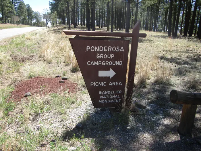
Ponderosa Group Campground is located 6 miles (9.7 km) from the park's main entrance and is an ideal place to stay for large groups visiting Bandelier National Monument. The campground is adjacent to Ponderosa Trailhead providing access to more than 70 miles (113 km) of hiking trails and is just a short drive from the Visitor Center, the Frijoles Canyon Shuttle System (mid-May to mid-October), and the town of Los Alamos, Valles Caldera National Preserve, Manhattan Project National Historic Site, and the Santa Fe National Forest.
Ponderosa Group Campground is open year-round (water is only available from mid-May to mid-October, subject to delays and/or early shut off). Same-day reservations are not permitted.
Frijoles Canyon and the park Visitor Center are accessible only by shuttle bus from mid-May to mid-October. The shuttle bus system stops at the Bandelier Visitor Center, Juniper Campground, and the White Rock Visitor Center in the town of White Rock. Outside of the designated shuttle bus period, visitors may access all park areas by private vehicle.
Public events are prohibited at Ponderosa Campground. Private events that adhere to campsite capacity limits, may be permitted after obtaining a special use permit. Visit the park's Permits & Reservations web page or call (505) 672-3861 ext. 1102.
Facilities
This campground is located at 7600 feet (2316 m) and is usually free of snow from mid-April through mid October. Water is not available during any months with freezing temperatures (potentially mid-October to mid-May).
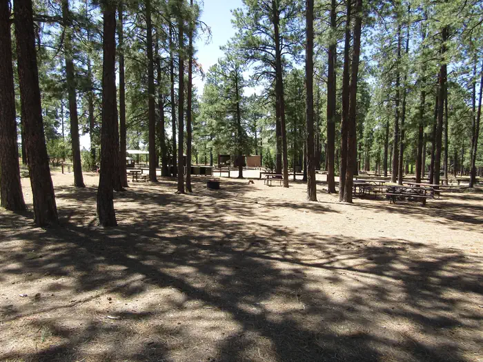
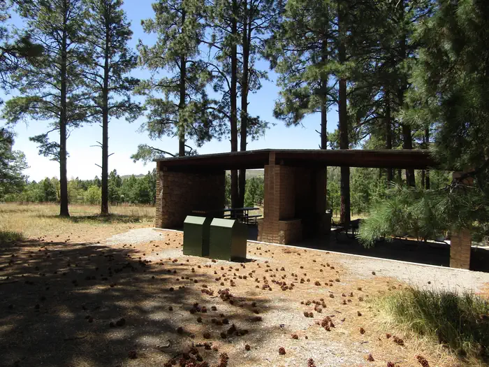
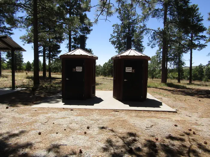
Vault toilets (with no running water), drinking water, a picnic shelter, picnic tables, food storage lockers, and campfire rings are provided at this facility. No hookup campsites are available. These sites are tent-only, but one RV per site can be accommodated in the parking area. Each site can accommodate between 10 and 50 people.
Check-in time for the campground is 4:00 pm.
Check-out time for the campround is 11:30 a.m.
Group Picnics: Sites can be reserved for large group picnics, however the fee and process is the same as reserving the site for an overnight stay.
Natural Features
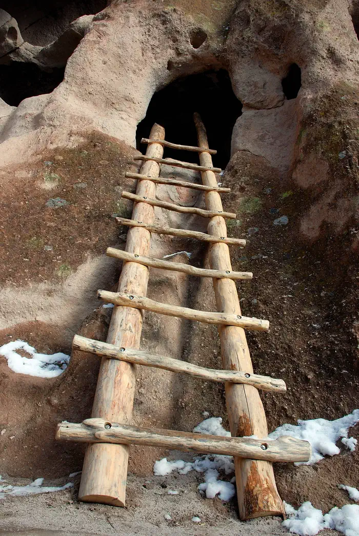
Bandelier National Monument protects over 33,000 acres (13,355 ha) of rugged, beautiful canyon and mesa country which features evidence of human presence going back over 11,000 years. Petroglyphs, dwellings carved into the soft rock cliffs, and standing masonry walls pay tribute to the early days of a culture that still survives in the surrounding communities.
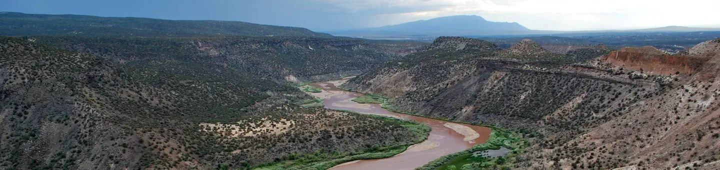
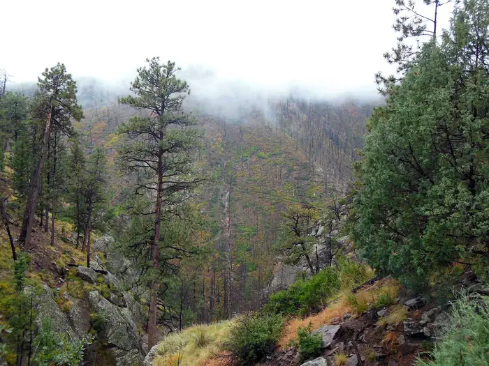
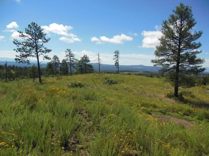
Bandelier National Monument sits at the southern end of the Pajarito (Spanish for "little bird") Plateau. The plateau was formed by two eruptions 1.6 and 1.4 million years ago. Home to the Bandelier Wilderness, Bandelier ranges from 5340 feet (1628 m) at the Rio Grande River to the south and 10,199 feet (3109 m) at the summit of Cerro Grande to the north, almost a mile (1.6 km) of elevation change in just under 12 miles (19 km). This elevation gradient creates a unique diversity of habitats specific to Northern New Mexico. The diversity of habitats and quick access to water supported a relatively large population of Ancestral Pueblo people. Currently, Piñon-Juniper woodlands dominate in the southern parts of the park transitioning through ponderosa pine savannahs and forests, finally reaching mixed conifer forests at the highest elevation. Scattered throughout the park are desert grasslands, montane meadows, and riparian areas in the canyon bottoms. Over 70 miles (113 km) of trails at Bandelier climb in and out of deep canyons and cross large flat mesas, showcasing the entire spectrum of volcanic geology and ecosystems found within the park.
The park is home to over 55 species of mammals including mule deer, Abert's squirrels, mountain lions, black bears, and 16 species of bats. Reptiles and amphibians of all shapes and sizes can be seen. Birds such as Steller's jays, canyon towhees and mountain chickadees stay year-round, whereas turkey vultures, western tanagers, and black-headed grosbeaks are summer residents.
Recreation
Accessible from Ponderosa Group Campground, the Ponderosa Trail descends into the park through ponderosa pine forest and connects to many other trails including the Middle Frijoles Trails which leads 8 miles (13 km) through Frijoles Canyon to the Visitor Center and Main Loop Trail.
The Visitor Center houses museum exhibits, park film, information and ranger programs, Western National Parks Association sales outlet, and more.
Entrance to Frijoles Canyon and the Visitor Center is by shuttle bus only from mid-May to mid-October. These areas are accesibile by private vehicle outside the shuttle bus period.
Although rock climbing is prohibited within Bandelier National Monument, many popular climbs are within a short drive up Route 4 into the Jemez Mountains.
Nearby Attractions
The town of Los Alamos has shopping, museums, amenities, a movie theater, ice rink, ski hill, and is home to the Los Alamos unit of Manhattan Project National Historic Site.
Nearby Department of Energy and US Forest Service lands provide trails which accommodate pets.
Valles Caldera National Preserve is 16 miles (26 km) west of Bandelier.
Jemez Historic Site is 37 miles (60 km) west.
Pecos National Historical Park is 70 miles (113 km) southeast.
Santa Fe, 40 miles (64 km) south of the park, is home to the New Mexico state capitol, museums, historic districts, art galleries, food, accomodations, and more.
Important Notices
Ponderosa Group Campground is available by reservation only. You may book reservations up to 12 months in advance until the day before arrival (subject to availability). There are no first-come, first-serve sites or same day reservations.
Entrance Fees. Bandelier National Monument charges an entrance fee separate from camping fees. You may pay the fee upon arrival at the automated fee machine at the Bandelier Entrance Station, at the Bandelier Visitor Center during business hours or purchase in advance. The park also honors Federal interagency passes (e.g., annual, senior, access, 4th grade, Golden Age pass etc.). For more information visit the park's Fees & Passes web page.
Check-in Time. Check-in time for group campsites is 4:00 p.m.
Check-out time. Check-out time for the campground is 11:30 a.m.
Quiet hours are from 10:00 p.m. to 6:00 a.m. and will be strictly enforced. All areas beyond campsites are closed after dusk to all public use. Generators may be used only from 8:00 AM to 8:00 PM
Tents only. Ponderosa Group Campground is for tent camping only, but you may park one RV per site in the parking area.
Parking. The use of all vehicles (including bicycles and trailers) is restricted to the parking area. All vehicles belonging to campers must be parked in the campground parking area – NOT in the trailhead parking area. Vehicles parked in the trailhead parking area after dark without a backcountry permit will be ticketed.
Food Lockers. Bears are known to be active in Bandelier National Monument. Please keep food, garbage and scented items locked up and unavailable to wildlife. Bear lockers are provided in the campground for storage of these items.
Pets. Pets are permitted in the campground, picnic area, and parking lot only and must be leashed at all times. Pets are not allowed on any hiking trails within the park.
Water Availability. Water is not available during months with freezing temperatures (potentially mid- October to mid-May). There are no shower or laundry facilities in the campground or in the park.
Minimum and Maximum Group Size. Camping at Ponderosa Group Campground is for groups of 10 to 50 persons per site. Camping is permitted only in the campsite for which campers have a reservation.
Prohibited activities. Group sports (volleyball, horseshoes, etc) are prohibited at campsites. Possession and/or use of fireworks or metal detectors is prohibited. Use of firearms is strictly prohibited and they may not be carried inside of government buildings. Digging or any other soil disturbance at campsites prohibited.
Firewood and Campfires. Gathering firewood is prohibited. During hot and dry summer months, fire restrictions are common and campfires and charcoal fires may be prohibited. Check the Alerts & Conditions page on the park website or call the Visitor Center for information on current fire restrictions.
Don't Move Firewood: Help protect our forests! Prevent the spread of tree-killing pests by obtaining firewood at or near your destination and burning it on-site. Moving firewood is illegal in some states. Visit dontmovefirewood.org to learn more.
Special Use Permits for Special Events. Public events are prohibited at Ponderosa Campground. Private events that adhere to campsite capacity limits, may be permitted after obtaining a special use permit. Visit the park's Permits & Reservations page or call (505) 672-3861 ext. 1102.
Available Activities
- Wildlife Viewing - Wildlife Viewing
- Picnicking - Picnicking
- Hiking - Hiking
- Camping - Camping
- Day Use Area - Day Use Area
- Wilderness - Wilderness
- Birding - Birding
- Star Gazing - Star Gazing
Directions
<p>From Santa Fe (appx 1 hour travel time):</p> <ul> <li>Take <strong>Highway 84/285</strong> (Saint Francis Drive) north toward Los Alamos.</li> <li>Merge right onto <strong>NM 502</strong> to Los Alamos.</li> <li>Exit onto <strong>NM 4</strong> toward White Rock.</li> <li>Continue for 12 miles (19 km), passing through White Rock.</li> <li>Bandelier's entrance is on the left. Enter here and purchase entrance pass(es) at the automated fee machine or continue on Entrance Rd for 3 miles (4.8 km) to the Visitor Center.</li> <li>Ponderosa Group Campground is 6 miles (9.7 km) past the park entrance on <strong>NM 4</strong>.</li> </ul> <p>From Taos (appx. 1.5 hours travel time): </p> <ul> <li>Take <strong>NM 68</strong> (Paseo del Pueblo Sur) south.</li> <li>In Espanola, turn right onto Fairway. </li> <li>Turn left on <strong>Highway 84/285</strong>.</li> <li>Turn right on<strong> NM 30</strong>.</li> <li>Merge right onto<strong> NM 502</strong> to Los Alamos.</li> <li>Exit onto <strong>NM 4</strong> toward White Rock.</li> <li>Continue for 12 miles (19 km), passing through White Rock.</li> <li>Bandelier's entrance is on the left. Enter here and purchase entrance pass(es) or continue on Entrance Rd for 3 miles (4.8 km) to the Visitor Center.</li> <li>Ponderosa Group Campground is 6 miles (9.7 km) past the park entrance on <strong>NM 4.</strong></li> </ul> <p>Visit the <a href="https://www.nps.gov/band/planyourvisit/directions.htm" rel="nofollow">Directions</a> page on the park website for detailed directions from other areas.</p>
Contact Information
Phone: (505) 672-3861
15 Entrance RoadLos Alamos, NM 87544
Rental Options
Available Campsites
- Site Group A, Loop PONDEROSA CAMPGROUND (NM), Type Group Standard Nonelectric
- Site Group B, Loop PONDEROSA CAMPGROUND (NM), Type Group Standard Nonelectric