Buffalo Point
BUFFALO POINT
Part of Buffalo National River
Overview
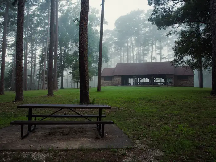
Buffalo Point is a convenient, fun-filled destination for families and adventurists of all types. It's perched along the Buffalo National River, providing exciting river sports and hiking opportunities. In peak season, a restaurant is open at the facility, serving up meals for those who want a break from preparing them.Facilities
Buffalo Point offers campsites with water, electricity and even a classic pay telephone. It's the only area in the park with a restaurant, open daily from Memorial Day to Labor Day and on weekends only from mid-April to Memorial Day Weekend and Labor Day Weekend to mid-October.
Natural Features
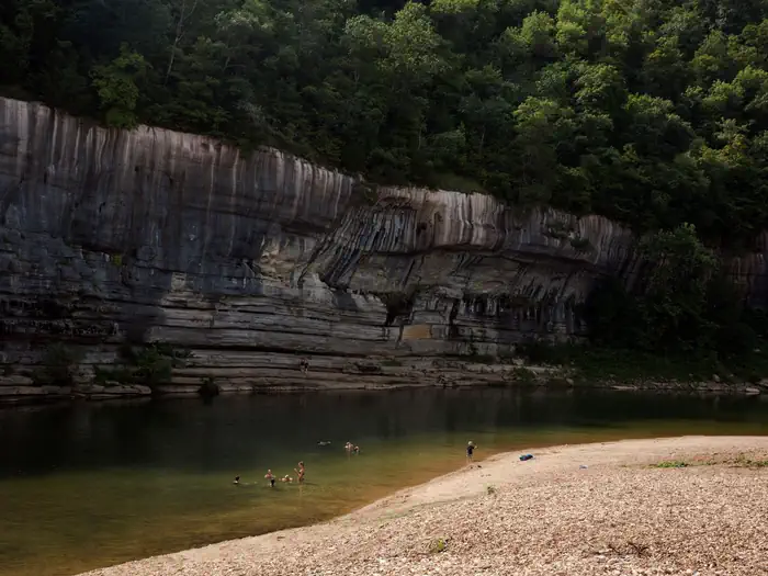
The campground is set along Buffalo National River, one of the few free-flowing rivers remaining in the contiguous United States. The river runs 135 miles without dams and cuts through the Arkansas Ozarks and into the White River. The region is surrounded by droves of lush hardwood trees and grassy open meadows.Recreation
The wild river is a gathering place for water activities. Many campers spend their days fishing, hiking, canoeing or kayaking. Evenings are ideal for gathering next to the fire to revamp for another great day out on the river.
Nearby Attractions
Two popular attractions within the Buffalo Point Area are the Indian Rockhouse Trail and the Rush Historic District. Rush was a zinc mining community until the zinc market collapsed and the settlement was deserted. Tours about the town's history are available. Buffalo Point is the former Buffalo River State Park developed in the 1930's as project of the Civilian Conservation Corps.
Blanchard Springs Caverns, an extraordinary living cave, is a one-hour drive from Buffalo Point.
Important Notices
Water and electricity is turned off form November 15th to March 14th each year.
The facility is available for camping free of charge outside of the reservation season.
Climbing and/or diving from the bluffs is dangerous and highly discouraged.
Do not swim alone during high water.
All park trails are closed to pets with the exception of the Buffalo River Trail, only on the section of trail between Ponca and Steel Creek, the Villines Homestead Trail at Ponca, the Mill Creek Trail (trailhead is at the Pruitt river access area in the Upper District), the Tyler Bend Campground trails (Spring Hollow, Buck Ridge, and Rock Wall in the Middle District), and all three Buffalo Point Campground trails (Forest Trail, Overlook Trail, and Campground Trail in the Lower District). For more information visit the Pets page on the park website.
Don't Move Firewood: Help protect our forests! Prevent the spread of tree-killing pests by obtaining firewood at or near your destination and burning it on-site. Moving firewood is illegal in some states.
Please be aware that some special events held at the pavilions or anywhere in the park (such as weddings, press receptions, concerts, et al) require a Special Use Permit in addition to the pavilion reservation. To obtain a Special Use Permit or additional information, please contact the Commercial Services office at (870) 365-2724. For more information visit the Special Park Uses web page. .
Please be advised that providing business services within an NPS unit is prohibited per CFR 5.3 without a written Authorization or Permit approved by the Superintendent. This includes services such as RV or tent delivery & set-up, firewood sales and delivery, shuttle (transportation) services, and guided hikes, floats, etc. For a list of approved visitor services and to learn more about working with Buffalo National River, please visit the our Doing Business with the Park web page. .
Available Activities
- SWIMMING SITE - Swimming
- DAY USE AREA - Amphitheater
- WILDLIFE VIEWING - Wildlife Viewing
- WATER SPORTS - Tubing
- VISITOR CENTER - Ranger Station
- HUNTING - Hunting
- HIKING - Hiking
- FISHING - Fishing
- INTERPRETIVE PROGRAMS - Educational Programs
- CAMPING - Camping
- HISTORIC & CULTURAL SITE - Historic Sites
- BOATING - Boating
- BIKING - Biking
Directions
<p><strong>From Springfield, MO:</strong> Take Highway 65 South through Branson to Harrison. Stay on Highway 65 through Harrison, turn left on Highway 62 and travel to Yellville. At Yellville turn right on Highway 14 East. Travel 17 miles (27 km) to Highway 268 East. Turn left on 268 to Buffalo Point. <br><br><strong>From Little Rock, AR: </strong>Take Highway 65 North to Marshall, at Marshall turn right on Highway 27 North about 11 miles (18 km) to Harriet. Turn left on Highway 14 West and travel about 14 miles (22.5 km) to Highway 268 East. Turn right on Highway 268 to Buffalo Point.</p>
Cancellation Policy
<p>Please see the Recreation.gov <a href="https://www.recreation.gov/rules-reservation-policies" rel="nofollow">Rules and Reservation Policies</a>. </p>
Contact Information
Phone: 870-449-4311
2229 HWY 268 EASTYELVILLE, AR 72687
Rental Options
Available Campsites
- Site Walk-in: I, Loop Tent only, Type Walk To
- Site C43, Loop Loop C, Type Standard Electric
- Site D57, Loop Loop D, Type Standard Electric
- Site Walk-in: E, Loop Tent only, Type Walk To
- Site D58, Loop Loop D, Type Standard Electric
- Site C50, Loop Loop C, Type Standard Electric
- Site Walk-in: K, Loop Tent only, Type Walk To
- Site Walk-in: S, Loop Tent only, Type Walk To
- Site A14, Loop Loop A, Type Standard Electric
- Site C48, Loop Loop C, Type Standard Electric
- Site E82, Loop Loop E, Type Standard Electric
- Site E78, Loop Loop E, Type Standard Electric
- Site A17, Loop Loop A, Type Standard Electric
- Site C44, Loop Loop C, Type Standard Electric
- Site P3, Loop Pavilions 1-3, Type Group Shelter Electric
- Site Walk-in: C, Loop Tent only, Type Walk To
- Site A10, Loop Loop A, Type Standard Electric
- Site C54, Loop Loop C, Type Standard Electric
- Site C39, Loop Loop C, Type Standard Electric
- Site D63, Loop Loop D, Type Standard Electric
- Site D62, Loop Loop D, Type Standard Electric
- Site D59, Loop Loop D, Type Standard Electric
- Site Walk-in: B, Loop Tent only, Type Walk To
- Site A20, Loop Loop A, Type Standard Electric
- Site B23, Loop Loop B, Type Standard Electric
- Site D55, Loop Loop D, Type Standard Electric
- Site A04, Loop Loop A, Type Standard Electric
- Site A02, Loop Loop A, Type Standard Electric
- Site Walk-in: H, Loop Tent only, Type Walk To
- Site A22, Loop Loop A, Type Standard Electric
- Site D61, Loop Loop D, Type Standard Electric
- Site A18, Loop Loop A, Type Standard Electric
- Site D65, Loop Loop D, Type Standard Electric
- Site P1, Loop Pavilions 1-3, Type Group Shelter Electric
- Site Walk-in: R, Loop Tent only, Type Walk To
- Site C46, Loop Loop C, Type Standard Electric
- Site A07, Loop Loop A, Type Standard Electric
- Site Walk-in: L, Loop Tent only, Type Walk To
- Site B32, Loop Loop B, Type Standard Electric
- Site C41, Loop Loop C, Type Standard Electric
- Site A12, Loop Loop A, Type Standard Electric
- Site C47, Loop Loop C, Type Standard Electric
- Site Walk-in: U, Loop Tent only, Type Walk To
- Site A05, Loop Loop A, Type Standard Electric
- Site B34, Loop Loop B, Type Standard Electric
- Site A21, Loop Loop A, Type Standard Electric
- Site A09, Loop Loop A, Type Standard Electric
- Site D75, Loop Loop D, Type Standard Electric
- Site B24, Loop Loop B, Type Standard Electric
- Site A08, Loop Loop A, Type Standard Electric
- Site C53, Loop Loop C, Type Standard Electric
- Site Walk-in: Q, Loop Tent only, Type Walk To
- Site B37, Loop Loop B, Type Standard Electric
- Site C40, Loop Loop C, Type Standard Electric
- Site B36, Loop Loop B, Type Standard Electric
- Site C45, Loop Loop C, Type Standard Electric
- Site B35, Loop Loop B, Type Standard Electric
- Site D74, Loop Loop D, Type Standard Electric
- Site G2, Loop Group Sites, Type Group Tent Only Area Nonelectric
- Site D76, Loop Loop D, Type Standard Electric
- Site Walk-in: F, Loop Tent only, Type Walk To
- Site B38, Loop Loop B, Type Standard Electric
- Site E79, Loop Loop E, Type Standard Electric
- Site B25, Loop Loop B, Type Standard Electric
- Site C51, Loop Loop C, Type Standard Electric
- Site G3, Loop Group Sites, Type Group Tent Only Area Nonelectric
- Site A16, Loop Loop A, Type Standard Electric
- Site B33, Loop Loop B, Type Standard Electric
- Site E81, Loop Loop E, Type Standard Electric
- Site B29, Loop Loop B, Type Standard Electric
- Site A19, Loop Loop A, Type Standard Electric
- Site D70, Loop Loop D, Type Standard Electric
- Site E77, Loop Loop E, Type Standard Electric
- Site D67, Loop Loop D, Type Standard Electric
- Site D68, Loop Loop D, Type Standard Electric
- Site D60, Loop Loop D, Type Standard Electric
- Site A03, Loop Loop A, Type Standard Electric
- Site Walk-in: J, Loop Tent only, Type Walk To
- Site Walk-in: N, Loop Tent only, Type Walk To
- Site Walk-in: G, Loop Tent only, Type Walk To
- Site Walk-in: P, Loop Tent only, Type Walk To
- Site Walk-in: M, Loop Tent only, Type Walk To
- Site D72, Loop Loop D, Type Standard Electric
- Site Walk-in: O, Loop Tent only, Type Walk To
- Site B30, Loop Loop B, Type Standard Electric
- Site B28, Loop Loop B, Type Standard Electric
- Site D73, Loop Loop D, Type Standard Electric
- Site E80, Loop Loop E, Type Standard Electric
- Site A11, Loop Loop A, Type Standard Electric
- Site E83, Loop Loop E, Type Standard Electric
- Site A01, Loop Loop A, Type Standard Electric
- Site G1, Loop Group Sites, Type Group Tent Only Area Nonelectric
- Site D69, Loop Loop D, Type Standard Electric
- Site D56, Loop Loop D, Type Standard Electric
- Site G4, Loop Group Sites, Type Group Tent Only Area Nonelectric
- Site D64, Loop Loop D, Type Standard Electric
- Site C49, Loop Loop C, Type Standard Electric
- Site P2, Loop Pavilions 1-3, Type Group Shelter Electric
- Site Walk-in: T, Loop Tent only, Type Walk To
- Site A13, Loop Loop A, Type Standard Electric
- Site B26, Loop Loop B, Type Standard Electric
- Site C52, Loop Loop C, Type Standard Electric
- Site Walk-in: D, Loop Tent only, Type Walk To
- Site D66, Loop Loop D, Type Standard Electric
- Site A06, Loop Loop A, Type Standard Electric
- Site A15, Loop Loop A, Type Standard Electric
- Site G5, Loop Group Sites, Type Group Tent Only Area Nonelectric
- Site B31, Loop Loop B, Type Standard Electric
- Site C42, Loop Loop C, Type Standard Electric
- Site D71, Loop Loop D, Type Standard Electric
- Site Walk-in: A, Loop Tent only, Type Walk To