Desoto Falls Recreation Area
Desoto Falls Recreation Area
Part of Chattahoochee-Oconee National Forest
Overview
Desoto Falls Recreation Area is a U.S. Forest Service Campground located approximately 2 hours North of Atlanta in the North Georgia mountains of the Chattahoochee National Forest. Desoto Falls offers visitors year-round recreation opportunities including camping, fishing, picnicking, and beautiful hikes to our nearby waterfalls. The campground is situated along Frogtown Creek with at an elevation of 2,080 feet above sea level, under a dense forest of deciduous and evergreen trees. 23 campsites are neatly arranged in two loops(upper and lower), with each loop having creek sites. The climate here is fairly mild and generally offers all four seasons, so it is a wonderful place to relax and experience each of these throughout the year. North Georgia is a playground for wildlife watchers. An abundance of Deer, Turkey, Bear and, small furbearers can be seen as well as bird watching. If you need to get away from the hustle and bustle of everyday life, come to Desoto Falls.
Facilities
April 1st through October 31st, the campground has drinking water, warm showers, and flush toilets. The bathhouse has warm water outdoor showers connected to a flush facility, and is located on the lower loop. Hydrants are centrally located throughout the entire campground for your convenience. Centrally located in the upper loop is a vault toilet, which is a short walk from most campsites. NOTE: There are no hookups or a dumpstation avaliable in the campground. From November 1st - March 31st, fees are reduced because no water is available.
A dumpster is located near site #3 for all bagged trash to be disposed of. Amenities include a picnic area, picnic tables, fire rings, vault toilets, lantern posts, drinking water, flush toilets, water hydrants, water front sites, and garbage service.
Natural Features
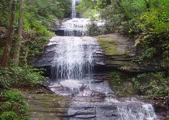
Desoto Falls is part of the Chattahoochee National Forest and is located in a 650-acre (2.6 km2) area designated as the Desoto Falls Scenic Area. This area of the Blue Ridge Mountains in Georgia make up part of the Appalachian Mountain range stretching all the way to Canada. The hardwood coves, rushing waterfalls, creeks, and steep canyons are crisscrossed with abundant trails for hiking and fishing. During the Month of October, North Georgia’s trees put on a vibrant show. Summer's dark greens change to brilliant reds, oranges and yellows which makes the camping atmosphere amazing. Thousands make the yearly trek into the mountains near Desoto Falls for a front row seat.
Recreation
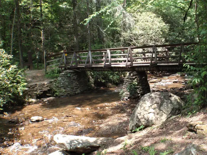
The primary attractions to this area are the two waterfalls along Frogtown Creek, which lead from the wooden bridge across from the Host Site. This hike is relatively short, kid-friendly distance and moderate elevation change make it one of North Georgia’s most popular waterfall hikes. .25 hike to lower falls and .75 to the upper falls. The trail hikes through several large exposed rock outcrops, beautiful rhododendron, and under the shade of several enormous old-growth pine trees with their wide trunks reaching high into the forest canopy above. The waterfall’s newly built observation deck makes a great spot for a mid-hike rest or picnic, and a great place to soak up the waterfall’s beauty.
Note: slippery rocks and fast moving water can be extremely dangerous! Please don’t climb, stand on, swim near, or jump from any waterfall.
Nearby Attractions
Just 1.5 miles north on 19/129 is Neels Gap and the Appalachian Trail. Drive just a short piece down to Byron Herbert Reece parking area on the left, and the Appalachian Trail can be easily accessed there. Nearby water falls to visit are are Helton Creek Falls, Dukes Creeks Falls, and Raven Cliffs Falls.
Just a short drive and located within the Chattahoochee-Oconee National Forests, the Brasstown Bald Recreation Area & Visitor Center is a great place to visit. It is the highest point in Georgia, rising 4,784 feet above sea level with a 360 degree view of four states.
Towns within a short drive to visit are Blairsville, Helen, and Dahlonega, GA
Important Notices
During non-peak season (November 1 - April 1), all water is turned off to the entire campground.
Be bear aware; keep all food in containers or locked inside a vehicle as much as possible. Remove all food from the area after eating and during nighttime hours. Dispose of garbage promptly in our bear proof garbage dumpster.
Limit of two vehicles per campsite except the double site (site #14), which is a maximum of 4 vehicles.
Quiet hours are from 10pm until 6am. No generators, music or other loud noises during this time. Be respectful to other campground visitors.
Campfires are permitted in grills only.
Pets must be on a leash at all times.
Discharging of firearms and fireworks is prohibited.
Do not leave fires unattended; they must be fully-extinguished and cold to the touch before check-out.
Note: cell phone service may not work in some areas due to tower location and terrain.
No day use or picnicking in the campground. Please use the day-use area or the picnic area if you do not have a reservation.
Available Activities
- Fishing - Fishing
- Hiking - Hiking
- Picnicking - Picnicking
- Camping - Camping
Directions
<p>From Blairsville, GA take U.S. Highway 19/129 South for 17.0 miles and the campground entrance is on your right. From Dahlonega, GA take Highway 19 North for 18 miles and the entrance in on your left. From Cleveland, GA, take 19/129 North for 16 miles and the entrance to the campground is on your left.</p>
Contact Information
Phone: 706-745-6928
Blue Ridge Ranger District2042 Highway 515 W
Blairsville, GA 30512 DeSoto Falls Recreation Area
18365 Highway 19
Dahlonega, GA 30533
Rental Options
Available Campsites
- Site 2, Loop A, Type Standard Nonelectric
- Site 18, Loop B, Type Standard Nonelectric
- Site 12, Loop B, Type Standard Nonelectric
- Site 4, Loop A, Type Standard Nonelectric
- Site 20, Loop B, Type Standard Nonelectric
- Site 22, Loop B, Type Standard Nonelectric
- Site 13, Loop B, Type Standard Nonelectric
- Site 8, Loop B, Type Standard Nonelectric
- Site 15, Loop B, Type Standard Nonelectric
- Site 10, Loop B, Type Tent Only Nonelectric
- Site 17, Loop B, Type Standard Nonelectric
- Site 1, Loop A, Type Standard Nonelectric
- Site 14, Loop B, Type Group Standard Nonelectric
- Site 7, Loop B, Type Standard Nonelectric
- Site 21, Loop B, Type Standard Nonelectric
- Site 3, Loop A, Type Standard Nonelectric
- Site 9, Loop B, Type Standard Nonelectric
- Site 5, Loop B, Type Standard Nonelectric
- Site 19, Loop B, Type Standard Nonelectric
- Site 11, Loop B, Type Tent Only Nonelectric
- Site 23, Loop B, Type Standard Nonelectric
- Site 16, Loop B, Type Standard Nonelectric
- Site 6, Loop B, Type Standard Nonelectric