Green River Float-IN Campsites
GREEN RIVER FLOAT-IN CAMPSITES
Part of Ashley National Forest
Overview
Take a step back in time and traverse the same scenic wonders that explorers such as John Wesley Powell and William Ashley once explored. The Green River provides spectacular fishing and river-running opportunities, as well as unique geology, outlaw history and Native American rock art. So come to navigate the waters and cast a rod in an adventure the whole family can enjoy.
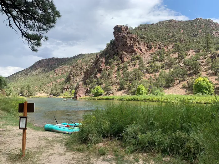
The Green River Float-In Campsites contain 17 sites for river goers to camp along the mighty Green River. Some of these sites can be reached on foot but most of these sites can only be reached by boat.
Facilities
All of the river camps are equipped with a picnic table, campfire ring with benches, tent pads and a blind for a portable toilet. No potable water is available.
Vault toilets can be found near Cottonwood Camp and Red Creek Camp.
Float-in distance from Boat Launch Areas to Campsite:
Stonefly I & II (river left)
Distance From Spillway Launch: 8.2 miles
Distance From Little Hole Launch: 1 mile
Accessible by Foot: Yes
Sand (river left)
Distance From Spillway Launch: 8.3 miles
Distance From Little Hole Launch: 1.1 miles
Accessible by Foot: Yes
Bootleg (river left)
Distance From Spillway Launch: 8.42 miles
Distance From Little Hole Launch: 1.22 miles
Accessible by Foot: Yes
Cats Paw (river left)
Distance From Spillway Launch: 8.55 miles
Distance From Little Hole Launch: 1.35 miles
Accessible by Foot: Yes
Cottonwood (river left)
Distance From Spillway Launch: 8.75 miles
Distance From Little Hole Launch: 1.55 miles
Accessible by Foot: Yes
Grasshopper I & II (river right)
Distance From Spillway Launch: 9.35 miles
Distance From Little Hole Launch: 2.15 miles
Accessible by Foot: No
Jackson Creek (river right)
Distance From Spillway Launch: 9.65 miles
Distance From Little Hole Launch: 2.45 miles
Accessible by Foot: No
Cicada (river right)
Distance From Spillway Launch: 9.9 miles
Distance From Little Hole Launch: 2.7 miles
Accessible by Foot: No
Trails End (river left)
Distance From Spillway Launch: 10 miles
Distance From Little Hole Launch: 2.8 miles
Accessible by Foot: Yes
Big Pine I & II (river left)
Distance From Spillway Launch: 10.5 miles
Distance From Little Hole Launch: 3.3 miles
Accessible by Foot: No
Pugmire Pocket (river right)
Distance From Spillway Launch: 10.75 miles
Distance From Little Hole Launch: 3.55 miles
Accessible by Foot: No
Red Creek I & II (river right)
Distance From Spillway Launch: 11.6 miles
Distance From Little Hole Launch: 4.4 miles
Accessible by Foot: No
Treetop (river right)
Distance From Spillway Launch: 12.2 miles
Distance From Little Hole Launch: 5 miles
Accessible by Foot: No
Natural Features
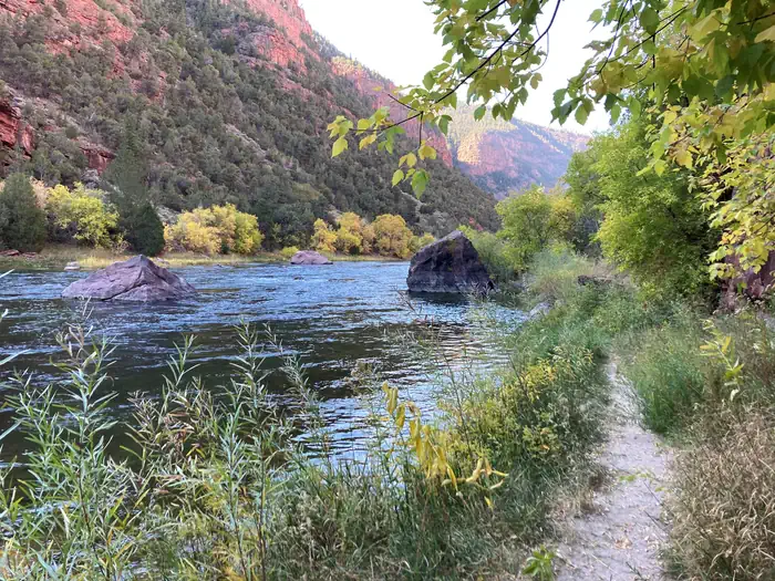
The campsites are nestled alongside the beautiful Green River in an area typical of a high desert environment. These sites are surrounded by shady juniper, cottonwood and ponderosa pine trees and during the summer various species of wildflowers dot the landscape.Recreation
Section "A" (Flaming Gorge Dam to Little Hole Boat Launch)
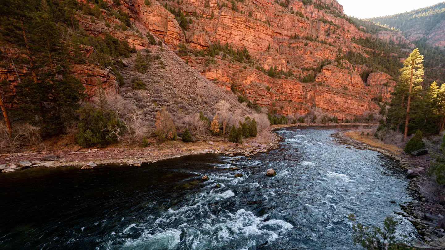
Section "A" of the Green River begins just below the Flaming Gorge Dam and proceeds seven miles through a narrow, breathtaking canyon to the Little Hole take-out. The towering red canyon cliffs, ponderosa pine, glassy clear water, abundant trout and rapids (class I and II) make section "A" of the Green River world famous. The Little Hole National Recreation Trail allows foot access to all seven miles of this stretch of river.
Section "B" (Little Hole to Browns Park)
It's a little more remote but that means there are fewer people, if that's the experience you're looking for. Limited access in this section allows for healthy brown trout populations to thrive.
There are 17 river camps in section "B" that can be accessed only by hiking or floating in.
Section "C" (Browns Park to the Utah/Colorado Border)
Section "C" is the longest of the three sections. It meanders through the high desert valley of Browns Park to the Colorado state line, with wide open features and a lot of flat water. It's considered the best place to catch a football size trout on a dry fly, but it is also said to be the most challenging for fishing.
The Green River offers excellent fishing for rainbow, brown and cutthroat trout. For more information on fishing the Green River, please visit Utah's Department of Wildlife Resources website .
Nearby Attractions
- Flaming Gorge National Recreation Area is known not only for its beautiful red cliffs but also for its world-class fishing, boating, hiking, camping, water skiing, jet skiing, canoeing, kayaking, swimming and scuba diving. Click Here to learn more about the Ashley National Forest and the Flaming Gorge National Recreation Area.
The Bureau of Reclamation offers guided tours of the Flaming Gorge Dams working hydroelectric plant and the dam itself; the adjacent visitor center contains area history exhibits.
In Browns Park, the Bureau of Land Management maintains the historic John Jarvie Ranch. Step back in time and explore the property where John ran a general store, trading post, post office and river ferry. Since Browns Park was a hiding place for outlaws, John became acquainted with many colorful members of Browns Parks history including, Butch Cassidy and the Sundance Kid of the Wild Bunch; outlaws Matt Warner and Isom Dart; and Queen of the Rustlers, Ann Bassett. Click Here for more information about the John Jarvie Ranch.
In the nearby town of Dutch John, there are several businesses that can provide services before and during your trip. These businesses include: - Flaming Gorge Recreation Services (435)885-3191 Raft Rental, Guided Fishing, Shuttle Service, General Store, Lodging, Bait, Gas
- Green River Outfitters (435)885-3338 - Raft Rental, Guided Fishing, Shuttle Service, General Store, Lodging, Bait, Gas
- Flaming Gorge Resort (435)889-3773 - Raft Rental, Guided Fishing, Shuttle Service, General Store, Lodging, Bait, Gas
Contact Info
For facility specific information, please call (435) 781-5244.Important Notices
- This is a boat-in facility, accessible by water; special regulations apply.
- An unofficial trail can be used to access select camps on foot.
- No potable water is available at the campsites.
Requirements to launch: boater must carry a bail bucket, throw line, extra oar and must wear a life jacket while on the water. No motors allowed.
- The Forest Service requires the use of portable toilet systems for all campers.
- This campsite is located in the Flaming Gorge National Recreation Area and will require the purchase of a Recreational Use Pass
- Don't Move Firewood: Help prevent the spread of tree-killing pests in our national forests by obtaining firewood near your destination and burning it on-site. For more information visit dontmovefirewood.org.
Available Activities
- WILDLIFE VIEWING - Wildlife Viewing
- HIKING - Hiking
- FISHING - Fishing
- CAMPING - Camping
- BOATING - Canoeing
Directions
<b> From Vernal, Utah: </b> Take U.S. Highway 191 north for 45 miles. Cross the Flaming Gorge Dam and turn right on the road leading to upper launch site at Spillway Boat Ramp. To launch from Little Hole continue on Highway 191 to the town of Dutch John and turn right on Little Hole Road. Follow that road for about 6 miles until you arrive at the Little Hole Boat Launch Area. <br /> <br /> <b> From Rock Springs, Wyoming: </b> Take U.S. Highway 191 south for 63 miles. Just before crossing the dam, turn left on the road to Spillway Boat Ramp, or at the town of Dutch John, turn left off Highway 191 and go east on Little Hole Road about 6 miles to Little Hole Boat Launch Area. <br /> <br />
Contact Information
Phone: (435)784-3445
P.O. BOX 279Manila, UT 84046
Rental Options
Available Campsites
- Site Stonefly II, Loop Green River, Type Boat IN
- Site Red Creek I, Loop Green River, Type Boat IN
- Site Red Creek II, Loop Green River, Type Boat IN
- Site Pugmire Pocket, Loop Green River, Type Boat IN
- Site Trails End, Loop Green River, Type Boat IN
- Site Cottonwood, Loop Green River, Type Boat IN
- Site Jackson Creek, Loop Green River, Type Boat IN
- Site Grasshopper II, Loop Green River, Type Boat IN
- Site Big Pine II, Loop Green River, Type Boat IN
- Site Sand, Loop Green River, Type Boat IN
- Site Bootleg, Loop Green River, Type Boat IN
- Site Treetops, Loop Green River, Type Boat IN
- Site Stonefly I, Loop Green River, Type Boat IN
- Site Cicada, Loop Green River, Type Boat IN
- Site Big Pine I , Loop Green River, Type Boat IN
- Site Grasshopper I, Loop Green River, Type Boat IN
- Site Cats Paw, Loop Green River, Type Boat IN