Scenic Byway 143 - Utah'S Patchwork Parkway
Overview
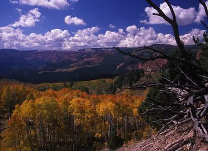
Scenic Byway 143 - Utah'S Patchwork Parkway is managed by Department of Transportation. Scenic Byway 143 - Utah’s Patchwork Parkway serves as the western gateway from the arid Great Basin of western Utah to a breathtaking route across Utah’s high plateaus, connecting to Heritage Highway 89 and Scenic Byway 12, Utah’s first All American Road. Historic pioneer communities “bookmark” each end of the route, once traveled by ancient inhabitants to hunt, fish, and gather tools and food. Early settlers desperate for food once crossed the plateau in midwinter using handmade quilts laid atop deep snow to reach settlements to the west. Such quilts are reminders of the patchwork of the byway's unparalleled scenery, vibrant history and natural beauty unequaled across the country. Today, travelers of Utah’s Patchwork Parkway begin their trek in historic communities where examples of early Mormon pioneer settlement and culture abound. The communities of Parowan and Panguitch contain a large concentration of 19th-century architecture and historic sites. The entire original Panguitch townsite is listed on the National Register of Historic Places. These two town sites were previously home to ancient native peoples who left behind an abundance of petroglyphs, pictographs, and more. Additional evidence indicates that these early inhabitants followed ancient migration routes into the high elevation expanses capped by Cedar Breaks National Monument, where vistas extend for hundreds of miles. This high elevation landscape is home to Brian Head, Utah’s highest elevation community and southernmost ski area, as well as other year-round resorts. Very few routes in the U.S. exhibit a 4,500-foot elevation change that crosses six major life zones in 51 miles. The route skirts lava flows only a few thousand years old before passing Panguitch Lake, a spectacular, large mountain lake renowned for its excellent fishing. This topmost rise of the geological “Grand Staircase” showcases the 2,000-foot-deep Cedar Breaks amphitheater with its vibrant hues of pink, orange, red, and other coral colors carved from the Claron Formation. The plateau provides views that extend for hundreds of miles and are home to some of the darkest night skies in the country.
Things to Do at Scenic Byway 143 - Utah'S Patchwork Parkway
Plan Your Visit
Getting There
Getting to the Byway:
Cedar City, UT
* Proceed north on Interstate 15 to Exit 75 in Parowan, UT, where the byway begins.
Denver, CO
- Proceed west on Interstate 70.
- Continue on I-70 into Utah.
- Continue on I-70 through the San Rafael Swell and Fishlake National Forest to the highway's intersection with US 89 at exit 23 in south-central Utah.
- Continue south on US 89 approximately 60 miles to Panguitch, the eastern gateway to Utah’s Patchwork Parkway.
Las Vegas, NV
* Proceed north on Interstate 15.
* Continue on I-15 into Nevada, then into Utah.
* Continue into Utah past St. George and Cedar City.
* Take exit 75 at Parowan, UT, which is the western gateway to Utah’s Patchwork Parkway.
Phoenix, AZ
- Proceed north from Phoenix on Interstate 17 to Flagstaff.
- Proceed north on US 89 to Page, AZ.
- Continue westward on US 89 to Kanab, UT.
- Turn north on US 89 to Panguitch, the eastern gateway to Utah’s Patchwork Parkway.
Salt Lake City, UT
* Proceed south on Interstate 15 past Provo, Nephi and Beaver.
* Take Exit 75 for Parowan, where the byway begins.
St. George, UT
* Proceed north on Interstate 15 to Exit 75 in Parowan, UT, where the byway begins.
Navigating the Byway:
* Begin your drive of Utah's Patchwork Parkway (SR 143) at Interstate 15 Exit 75 in Parowan. Proceed east.
* After leaving Parowan, the route enters Parowan Canyon and climbs 4,400 feet in less than 10 miles.
* Continue on SR 143 past Brian Head, Utah’s highest elevation community and southernmost ski resort, located at the top of the canyon.
* Enter Cedar Breaks National Monument.
* Follow SR-143 eastward across 12 miles of high alpine meadows known as “Little Ireland.”
* Continue past Panguitch Lake.
* Descend 18 miles through South Canyon in the Dixie National Forest.
* The byway ends in Panguitch City at the junction with US 89.
Contact & Resources
Phone: 435-865-3700
Additional Information: