King Range Wilderness Permits (Lost Coast)
IMPORTANT: Before purchasing a permit for the Lost Coast Trail, you must CHECK THE TIDES for your preferred dates to ensure PASSABLE TIDE WINDOWS (see "Tides" below).
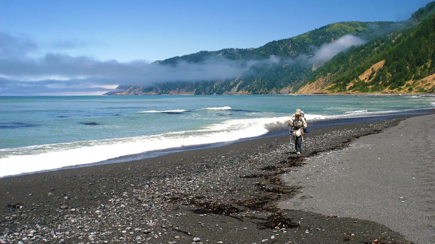
The Bureau of Land Management's (BLM) King Range Wilderness is a spectacular meeting of land and sea, as its mountains seem to thrust straight out of the surf, a dramatic rise rarely surpassed on the continental U.S. coastline. King Peak, the highest point at 4,088 feet, is only three miles from the ocean. The landscape is too rugged for highways and accessible by only a few rural roads, earning its name, “The Lost Coast”. The King Range Wilderness offers 85 miles of backpacking opportunities on trails that traverse upland mountain ridges, coastal bluffs, and beaches. The world-famous Lost Coast Trail runs 25 miles between Shelter Cove and Petrolia, CA. Visit the King Range NCA website and use the Trip Planning Guide and the updated topographic Map to plan your visit.
Tides must be checked for your preferred dates, prior to purchasing a permit for the Lost Coast Trail. See the Guide to Tide Safety and Tide Safety Video for instructions on how to use the NOAA website to plan your itinerary for passable tide windows. Find impassable zones on the King Range topographic Map .
Impassable Zones & Tide Level Thresholds: On a normal day, there are 3 trail sections where the tide must be under a specific threshold (in feet) to ensure safe passage. In these “impassable zones”, the beach is very narrow, there are large boulders to traverse, and no grassy bluffs for refuge—mostly vertical bedrock walls. If the tide is too high, there is nowhere to escape the dangerous North Coast waves.
Zone 1: Punta Gorda (¼ mile): passable under ~6 ft. tide.
Zone 2: Sea Lion Gulch to Randall Cr. (4 miles): passable under 2.5 ft. tide.
Zone 3: Miller Cr. to Gitchell Cr. (4.5 miles): passable under 3 ft. tide.
Always enter the impassable zones on a receding tide and plan travel at 1mph.
Impassable Dates 2026: Tides don't fall low enough to allow passage along the Lost Coast Trail:
July 23
August 7, 8, 20, 21, 22
September 4, 5, 6, 7, 17, 18, 19, 20, 21
October 2, 3, 4, 5, 16, 17, 28, 28, 30
November 1, 2, 14, 15, 16, 17, 28, 29, 30
December 13, 14, 15, 16, 27
The BLM does not recommend hiking at night due to inherent dangers like slippery boulders, wildlife, large waves, etc.
Check Marine Forecast & Weather prior to your trip:
There have been many accidents, close calls, and deaths due to poor planning for impassable zones, marine conditions, and unfavorable weather. BLM does not have a search & rescue team. Proper planning is imperative.
Earthquakes & Tsunami
If a strong earthquake occurs while you are on the beach, move to higher ground immediately! The Lost Coast is home to the Mendocino Triple Junction near Cape Mendocino and is one of the most seismically active regions in California.
Notifications and Alerts
2026 Lost Coast Trail Impassable Dates:
July 23
August 7, 8, 20, 21, 22
September 4, 5, 6, 7, 17, 18, 19, 20, 21
October 2, 3, 4, 5, 16, 17, 18, 19, 20, 30, 31
November 1, 2, 14, 15, 16, 17, 28, 29, 30
December 13, 14, 15, 16, 27
The BLM does not recommend hiking at night due to inherent dangers like slippery boulders, wildlife, large waves, etc.
Check daily SWELLS and watch for SNEAKER WAVE warnings.
WET WIPES: Park Rangers are finding and packing out hundreds of wet wipes on the trail.
Many conventional baby wipes do not easily biodegrade while plastic-free and “biodegradable” wipes require oxygen to decompose efficiently. No one wants to see your wet wipes and toilet paper, and they don't want to camp next to your human waste.
PLEASE pack out your toilet paper and wet wipes and always make your "deposit" in a six-inch-deep hole in the intertidal zone (between water and high tide mark)--not in or anywhere near campsites!
Please practice LEAVE NO TRACE principles on the Lost Coast Trail and in the King Range NCA.
COYOTE ALERT:
Coyotes are typically wary of people but are wild animals and should be treated with appropriate respect. Please follow the guidelines below to help minimize conflict:
1. Be aware of your surroundings.
2. Keep pets on leash and under control.
3. Keep your distance – do not approach a coyote. In the unlikely event that a coyote approach you, maintain eye contact, make yourself large, wave your arms and clap, and shout in a loud aggressive voice.
4. Never feed coyotes. Keep wildlife wild.
A large colony of elephant seals, including pups, is currently on the beach and bluff between Punta Gorda (1.5 miles south of Mattole Campground and Trailhead) and Sea Lion Gulch. Please follow these guidelines to stay safe and avoid disturbance:
Stay Alert - at first glance they may blend in with their surroundings.
Give seals plenty of space - disturbances can cause them to take to the water, which can be life-threatening to them at this point in their lifecycle.
After you cross Fourmile Creek (when heading south) stay on the bluff trail.
Keep pets leashed and under control at all times.
Camp away from the colony - some areas may appear suitable but are actively being used by seals as more arrive.
Additionally, avoid contact with dead birds, bones, feathers and seal poop - Avian influenza has been detected in areas along the California coast.
New Hours for King Range NCA Visitor Center: Monday-Saturday 8:00am-4:30pm through Labor Day weekend. Closed federal holidays.
IMPORTANT: NO CAMPFIRES allowed anywhere in the King Range Wilderness between June 19 and September 30. Camp stoves are allowed, use extreme caution.
Permit & Season Information
Wilderness permits are required for overnight use in the King Range Wilderness. Day use does not require a permit.
Permits are available on an a 90-day rolling reservation system and may be reserverd 90-days prior to entry at 7:00 am PST. For example: on 10/1/25, permits will open for 1/1/26; on 10/2/25 for 1/2/26, etc. Permittees are allowed one active permit at a time.
Organized and Commercial groups must obtain a Special Recreation Permit (i.e. outfitters, scout troops, schools, etc.). The maximum group size is 15 people.
Walk up permits for up to 3 starts (people) are available at the King Range Visitor Center by lottery which will be conducted Mon-Sat at 8:00am. Walk up permits that are still available after the lottery will be issued first come/first served.
Permit isn’t officially issued until printed. The permit must be carried by the permittee. You may print your permit 7 days before your entry date. Once your permit has been printed, you cannot make changes.
Need to Know
Important Safety & Trip Planning Info:
Impassable Zones
ALERT: There are 3 sections on the Lost Coast Trail that are impassable at certain tide levels.
#1: Punta Gorda--passable under 6 ft
#2: Sea Lion Gulch to Randall Creek--passable under 2.5 ft
#3: Miller Flat to Gitchell Creek--passable under 3 ft
Before purchasing permits, watch Tide Safety Video . Properly plan your trip itinerary to ensure your safety and ability to pass, PRIOR to purchasing a permit.
“Low tide” does NOT EQUAL “passable”. There are dates that the low tide does not fall under the passable threshold. In other words, just because its “LOW TIDE”, it doesn’t mean the trail is safe to pass. Always use the above thresholds to determine a passable tide window through each impassable zone.
DO NOT ASSUME that if permits are for sale, the dates are passable on LCT. These permits are for the entire King Range Wilderness, including the upland trails.
Watch the ocean! Especially on sloped beaches, avoid walking near the water because forceful waves can surge up at any time without notice (sneaker waves). The ocean on the Lost Coast can sweep a person off their feet, out to sea, and to their death at any time.
Never attempt to swim or wade on this stretch of the Pacific Ocean due to strong undertow and rip currents. The water is very cold, and survival is often limited to 20 minutes without a wetsuit. Don’t ever assume it is ok to “just get a bit wet” to pass through impassable zones.
Weather can change drastically; be prepared with a backup plan. From October thru April, the King Range Wilderness is one of the wettest spots in the U.S. with annual rainfall averaging 120 inches. Storms can make coastal creeks impassable very fast. Never attempt to cross creeks above knee height. Wait for water to subside.
Check the marine forecast just before your trip. Find the forecast for Cape Mendocino to Point Arena. Note the winds, wave height, and period/seconds.
Campfire Permit is REQUIRED! A campfire permit is required from CAL FIRE to operate camp stoves and campfires. Find Campfire Permit here.
Hard-sided Bear Canisters are required. The canister must be of appropriate size to store all scented items including food, soap, sunscreen, and trash. Each person must possess a minimum of one canister. Bags are not allowed. Visitors failing to use hard-sided canisters are subject to fines (43 CFR 8365.1-6). Bear can rental provided at the King Range Visitor Center.
Drinking Water is usually available in year-round coastal creeks and springs. Always treat your water using an approved filtration method or by boiling it. Water sources may be scarce along upland trails, so bring plenty of water, especially in dry years.
Other Hazards Ticks, poison oak, and rattlesnakes are common. Be able to identify and avoid them. Poison oak grows all over the KRNCA in many forms—vines on trees, bushes along coast bluffs, and even small waxy plants in the sand. Ticks are also present, especially in spring/early summer. Rattlesnakes hide under large driftwood and sometimes lay on the trail. Avoid all these hazards by remaining aware of your surroundings.
Dogs are not recommended.
Frequently Asked Questions
Do I have to start my hike on the Entry Date listed on my permit? Yes, the correct Entry Date is required, no exceptions.
Do I need a permit for day use in the King Range Wilderness? No, permits are required for overnight use only.
Can I transfer my permit to another person? No, permits are non-transferable.
How do I cancel my permit if I decide to not go? Cancel on Recreation.gov account. Reservation fee is non-refundable. Wilderness Area fee is only refundable if at least 7 days prior to entry date.
How many people can hike together in a group? All organized and commercial groups need a Special Recreation Permit, no exceptions. Max. SRP size=15.
Why should I check the marine forecast in addition to the weather? Weather, wind, and ocean swells may affect the ability to traverse safely on the LCT. A large swell can shorten the amount of time to get through a tidal zone safely. Long period secondary swells can mean an increased likelihood of sneaker waves. This can mean life or death-hazardous ocean conditions have resulted in hikers being swept out to sea.
Can I swim in the ocean? No. Never ever swim, wade, or use skim boards in the ocean anywhere on the Lost Coast due to rip currents, strong undertow, and sneaker waves.
Who is responsible for making sure our group is safe on the LCT? It is your duty as a permit holder to ensure each person on your permit is aware of all rules & safety concerns. The BLM does NOT have a Search & Rescue team. Assume self-extrication. Carry In-Reach device for extreme emergencies.
Who is checking permits? Rangers at the trailheads and on trail.
Are hard-sided bear canisters are required? Yes, bear cans are required. Bear bags/hangs are NOT acceptable. Cans are available for rent in several King Range locations.
Where do I use the bathroom on the LCT? Deposit solid human waste in a hole dug 6" deep in the intertidal zone. Never go near backcountry campsites. In uplands, 200 feet from fresh water, camp, and trails. Always pack out your toilet paper in your bear can.
How deep are the creek crossings? Heavy rainfall will cause water levels in the creek to rise to unsafe levels. Do not cross if over knee high. Be prepared for changing weather and call visitor center for current conditions.
Can I have a campfire? It depends on the time of year. You must have a CalFire Campfire permit in addition to a Wilderness Permit. Use existing campfire rings and always put fire out before bed or leaving site. Campfires are prohibited July through October.
Can I bring my drone in the wilderness and Lost Coast Trail? DRONES are NOT allowed.
Additional Information here: https://www.recreation.gov/permits/445864/additional-information
King Range Visitor Center Hours: Monday-Saturday 8:00am-4:30pm through Labor Day weekend. Closed federal holidays.
Fee Policy
Reservation Fee & Special Area Fee
For individuals and family groups:
Reservation Fee: $6 per permit
Special Area Fee*: $12 per person, per trip (No fee for youth under 16)
Special Recreation Permit (SRP): Organized and Commercial group fees
Organized group fee: $7 per person, per day
Commercial group fee: 3% of total gross earnings
Commercial group fee (institutional): $7 per person, per day
Special Area Fee*: $12 per person, per trip (No fee for youth under 16)
There is a minimum $130 fee for all SRP groups. A deposit is due with submission of the application.
For more SRP Information and to request information on how to apply for an SRP, call the King Range Visitor Center (707) 986-5400.
*The King Range Wilderness Special Area Fee is new and based on King Range Business Plan, 2024 and Federal Register Notice. Fees remain in King Range Wilderness to assist maintenance, stewardship and education.
Cancellation Policy
Change Policy
- The permit is non-transferable.
- The permittee must be on the trip and carrying the permit at all times.
- The group size can be reduced or increased prior to printing your permit. Please note that increases in group size will only be accommodated up to the availability for the permitted entry day for your group. Group size reductions must be made at least 7 days prior to the reserved Entry Date to receive a refund of the Special Area Fee.
Cancellation Policy
- The $6 reservation fee is non-refundable. As a courtesy to other users, please cancel your permit or reduce your group size as needed to free up spots for other hikers.
- The Special Area Fee is refundable only if cancellation or group size reduction occurs at least 7 days prior to the reserved Entry Date.
Contact Information
Mailing Address
768 Shelter Cove Road (Physical address) Whitethorn CA 95589
Office Hours: 8:00a.m. – 4:30 p.m., Monday through Friday, Pacific Standard Time
Phone Number
(707) 986-5400